
Source: Bureau of Meteorology
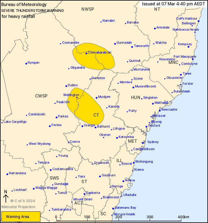
For people in parts of Central Tablelands, North West Slopes and
Plains and Central West Slopes and Plains Forecast Districts.
Issued at 4:40 pm Thursday, 7 March 2024.
Severe thunderstorms continuing about the central west.
Weather Situation: Heavy rainfall is possible from slow moving
thunderstorms triggering on a southerly change in a moist unstable
airmass. Severe thunderstorms will remain possible into the
evening, although the risk will gradually ease as the change moves
through.
Severe thunderstorms are likely to produce heavy rainfall that may
lead to flash flooding in the warning area over the next several
hours. Locations which may be affected include Coonabarabran,
Wellington, Hill End and Tambar Springs.
Severe thunderstorms are no longer occurring in the Hunter
district and the warning for this district is CANCELLED.
The State Emergency Service advises that people should:
* Keep clear of creeks and storm drains.
* Don't walk, ride your bike or drive through flood water.
* If you are trapped by flash flooding, seek refuge in the highest
available place and ring 000 if you need rescue.
* Be aware that run-off from rainfall in fire affected areas may
behave differently and be more rapid. It may also contain debris
such as ash, soil, trees and rocks.
* After bushfires, heavy rain and the loss of foliage can make the
ground soft and heavy, leading to a greater chance of
landslides.
* Unplug computers and appliances.
* Avoid using the phone during the storm.
* Stay indoors away from windows, and keep children and pets
indoors as well.
* Stay vigilant and monitor conditions. Note that the landscape
may have changed following bushfires.
* For emergency help in floods and storms, ring the SES (NSW and
ACT) on 132 500.
07/Mar/2024 05:47 AM


