
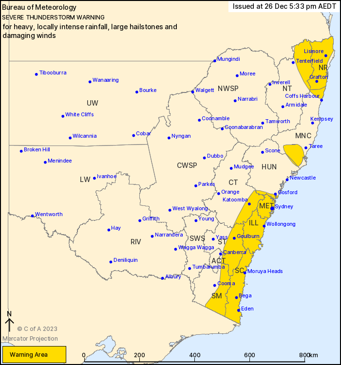
Source: Bureau of Meteorology
For people in Northern Rivers, Metropolitan, Illawarra, South
Coast and parts of Mid North Coast, Hunter, Central Tablelands,
Southern Tablelands, Snowy Mountains, Northern Tablelands and
Australian Capital Territory Forecast Districts.
Issued at 5:33 pm Tuesday, 26 December 2023.
INTENSE RAINFALL developing east of the ACT. Severe storms
continuing further north, becoming isolated north of Sydney.
Weather Situation:
A low-pressure system situated in the southwest of the state and
its associated front lies over the South West Slopes and Plains. A
trough then extends further north along the Great Dividing Range to
the Queensland border. A humid and very unstable airmass along and
to the east of the trough, supported by strong upper winds, will
bring the risk of severe thunderstorms into this evening.
Storms are generally forecast to move to the south and
southeast.
Severe thunderstorms are likely to produce heavy, locally intense
rainfall that may lead to dangerous and life-threatening flash
flooding, large hailstones and damaging winds over the next several
hours in parts of the South Coast, Southern Tablelands, Snowy
Mountains and Australian Capital Territory districts. Locations
which may be affected include Braidwood, Bega, Araluen, Captains
Flat and Nimmitabel.
Severe thunderstorms are likely to produce large hailstones, heavy
rainfall that may lead to flash flooding and damaging winds over
the next several hours in the Northern Rivers, Metropolitan,
Illawarra, South Coast and parts of the Mid North Coast, Hunter,
Central Tablelands, Southern Tablelands, Snowy Mountains, Northern
Tablelands and Australian Capital Territory districts. Locations
which may be affected include Lismore, Grafton, Sydney, Wollongong,
Nowra, Batemans Bay and Goulburn.
Snowball (SE of ACT) recorded 57mm in the 1 hour to 5:23pm.
4 to 5 cm hailstones were reported in the Rutherford and Maitland
area between at 1:30 and 2 pm.
Willina (near Forster) recorded 48mm in the 30 minutes to
3pm.
Maroota (Upper Hawkesbury) recorded 47 mm in the 1 hour to
4pm.
High Range (Wanganderry) recorded 32 mm in the 30 mins to
4:30pm.
The State Emergency Service advises that people should:
* Move your car under cover or away from trees.
* Secure or put away loose items around your house, yard and
balcony.
* Keep at least 8 metres away from fallen power lines or objects
that may be energised, such as fences.
* Report fallen power lines to either Ausgrid (131 388), Endeavour
Energy (131 003), Essential Energy (132 080) or Evoenergy (131 093)
as shown on your power bill.
* Trees that have been damaged by fire are likely to be more
unstable and more likely to fall.
* Keep clear of creeks and storm drains.
* Don't walk, ride your bike or drive through flood water.
* If you are trapped by flash flooding, seek refuge in the highest
available place and ring 000 if you need rescue.
* Be aware that run-off from rainfall in fire affected areas may
behave differently and be more rapid. It may also contain debris
such as ash, soil, trees and rocks.
* After bushfires, heavy rain and the loss of foliage can make the
ground soft and heavy, leading to a greater chance of
landslides.
* Unplug computers and appliances.
* Avoid using the phone during the storm.
* Stay indoors away from windows, and keep children and pets
indoors as well.
* Stay vigilant and monitor conditions. Note that the landscape
may have changed following bushfires.
* For emergency help in floods and storms, ring the SES (NSW and
ACT) on 132 500.
26/Dec/2023 07:20 AM


