
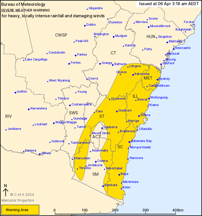
Source: Bureau of Meteorology
For people in Metropolitan, Illawarra, South Coast, Southern
Tablelands and parts of Central Tablelands, South West Slopes,
Snowy Mountains, Australian Capital Territory and Hunter Forecast
Districts.
Issued at 3:18 am Saturday, 6 April 2024.
Widespread heavy to LOCALLY INTENSE RAINFALL and damaging wind
gusts expected about central parts of the coast and ranges this
morning, moving south.
Weather Situation: A trough is deepening along the New South Wales
coast during this morning, under the influence of a slow-moving
upper-level low over central New South Wales. Areas of heavy rain
and gusty showers and a few thunderstorms will become more
widespread south of about Gosford, including over the ranges and
tablelands. Severe weather has started easing from the north and
will continue to do so this morning as the trough moves southeast
to the Tasman Sea.
HEAVY RAINFALL which may lead to FLASH FLOODING is forecast for
the Sydney Metropolitan, Illawarra, and Central Tablelands,
Southern Tablelands and South Coast, while easing from the north.
Six-hourly rainfall totals between 50 to 90 mm are likely, reaching
up to 130 mm over the Blue Mountains and Illawarra escarpment. 24
hour totals of 70 to 120 mm are also likely, reaching up to 150 mm
over the Blue Mountains and Illawarra escarpment.
Within the broad heavy rainfall area, locally INTENSE RAINFALL
which may lead to DANGEROUS AND LIFE-THREATENING FLASH FLOODING is
possible between the Blue Mountains and Narooma this morning, then
extending further south later today with localised six-hourly
rainfall totals between 90 to 150 mm possible, reaching up to 220
mm over the Illawarra escarpment. Localised 24-hourly rainfall
totals between 120 and 200 mm are possible, and may reach up to 300
mm over the Illawarra escarpment. A separate Severe Thunderstorm
Warning will be issued if very dangerous thunderstorms with intense
rainfall are detected.
DAMAGING EASTERLY WINDS, averaging 60 to 70 km/h with peak gusts
of around 90 km/h are possible in the South West Slopes and along
the coastal strip south of and including coastal parts of the
Sydney Metropolitan area, as well as adjacent elevated areas,
particularly above 500 metres.
DAMAGING WINDS averaging 80 to 90 km/h with peak gusts in excess
of 125 km/h are likely for alpine areas above 1900 m, easing late
Saturday morning.
The widespread severe weather risk is forecast to clear south of
the Hunter and Sydney Metropolitan areas by sunrise on Saturday,
the Illawarra by late Saturday morning and the South Coast by
Saturday afternoon. More isolated severe thunderstorms may
redevelop on Saturday afternoon.
A Flood Watch and several Flood Warnings are current over the
area.
A Severe Weather for Damaging Surf is current.
Please refer to http://www.bom.gov.au/nsw/warnings/index.shtml for
more information on other Watches and Warnings.
Locations which may be affected include Sydney, Wollongong, Nowra,
Batemans Bay, Goulburn, Cabramurra and Yass.
Baerami recorded 66 mm in 6 hours to 9:07pm.
Nullo Mountain recorded 69 mm in 6 hours to 9:23pm.
Cabramurra recorded a wind gust of 94km/h at 2:49am
The State Emergency Service advises that people should:
* Don't drive, ride or walk through flood water.
* Keep clear of creeks and storm drains.
* If you are trapped by flash flooding, seek refuge in the highest
available place and ring 000 if you need rescue.
* Be aware that run-off from rainfall in fire affected areas may
behave differently and be more rapid. It may also contain debris
such as ash, soil, trees and rocks.
* After bushfires, heavy rain and the loss of foliage can make the
ground soft and heavy, leading to a greater chance of
landslides.
* Move vehicles under cover or away from trees.
* Secure or put away loose items around your house, yard and
balcony.
* Keep at least 8 metres away from fallen power lines or objects
that may be energised, such as fences.
* Trees that have been damaged by fire are likely to be more
unstable and more likely to fall.
* Report fallen power lines to either Ausgrid (131 388), Endeavour
Energy (131 003), Essential Energy (132 080) or Evoenergy (131 093)
as shown on your power bill.
* Stay vigilant and monitor conditions. Note that the landscape
may have changed following bushfires.
* For emergency help in floods and storms, ring your local SES
Unit on 132 500.
05/Apr/2024 04:39 PM


