
Source: Bureau of Meteorology
For people in parts of Mid North Coast, Metropolitan and Hunter
Forecast Districts.
Issued at 9:26 am Tuesday, 9 April 2024.
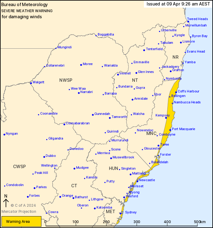
Damaging wind gusts to develop about the coastal fringe between
Wooli and Wattamolla from early Wednesday morning.
Weather Situation: A low pressure system is forecast to develop
off the east coast tonight and through Wednesday. It is expected to
produce a vigorous southerly flow on its western flank.
DAMAGING WIND GUSTS with peak gusts of around 100 km/h are
possible about the coastal fringe between Wooli and Wattamolla from
early Wednesday morning. The wind risk is expected to contract from
the south to the Hunter and Mid North Coast districts around
mid-morning on Wednesday.
Damaging wind gusts are forecast to ease below warning thresholds
by late Wednesday afternoon.
A separate warning for HAZARDOUS SURF is current for the east
coast north of Ulladulla.
Locations which may be affected include Sydney coast, Coffs
Harbour, Port Macquarie, Newcastle, Woolgoolga, Sawtell and The
Entrance.
The State Emergency Service advises that people should:
* Move vehicles under cover or away from trees.
* Secure or put away loose items around your house, yard and
balcony.
* Keep at least 8 metres away from fallen power lines or objects
that may be energised, such as fences.
* Trees that have been damaged by fire are likely to be more
unstable and more likely to fall.
* Report fallen power lines to either Ausgrid (131 388), Endeavour
Energy (131 003), Essential Energy (132 080) or Evoenergy (131 093)
as shown on your power bill.
* Stay vigilant and monitor conditions. Note that the landscape
may have changed following bushfires.
* For emergency help in floods and storms, ring your local SES
Unit on 132 500.
08/Apr/2024 11:34 PM


