
Source: Bureau of Meteorology
Issued at 10:49 am CST on Friday 29 March 2024
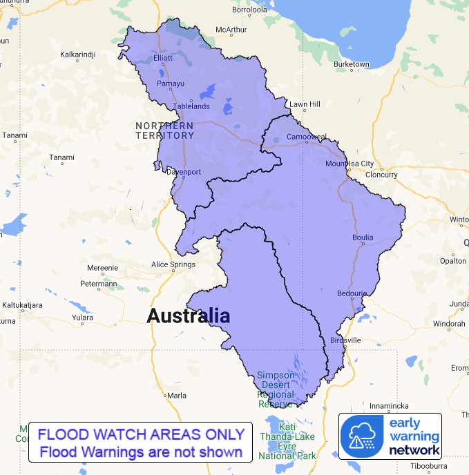
Flood Watch Number: 25
FLOODING POSSIBLE FOR CENTRAL AND EASTERN INTERIOR PARTS OF THE
NORTHERN TERRITORY
A slow moving trough near Queensland and Northern Territory border
will bring tropical moisture southwards. Moderate to heavy rainfall
is likely across Eastern Interior parts of the Northern
Territory.
Catchments in the Flood Watch area are relatively wet and
responsive to rainfall, and river levels remain elevated in parts
of the Flood Watch area.
Rain and thunderstorms are forecast over the next few days.
Scattered daily rainfall totals of 5-15 mm with isolated heavier
falls up to 40 mm is possible across the Flood Watch area during
Friday. Rainfall totals are likely to increase to 15-35 mm with
isolated falls up to 60 mm during Saturday and Sunday.
The recent observed rainfall is causing flooding impacts, and with
further rainfall forecast, impacts will continue over the coming
days. Flood impacts may include road closures, including primary
and secondary highways, and isolation of communities and
homesteads. Check road conditions before travelling.
Catchments likely to be affected include:
Barkly
Simpson Desert
Georgina River and Eyre Creek
Flooding is no longer expected in the following catchments: Upper
Victoria River, Victoria River below Kalkarindji.
See www.bom.gov.au/australia/warnings to view all of the Bureau's
current warning products.
More information on the Flood Watch Service and maps of Flood
Watch areas are available at
www.bom.gov.au/water/floods/floodWarningServices.shtml .
Flood Safety Advice:
The Northern Territory Emergency Service advises that people
should:
* Stay away from flooded drains, rivers, streams and
waterways.
* Prepare for flooding and move away while safe to do so.
* Don't drive into floodwaters.
For emergency help in floods, storms and cyclones call 132
500.
Emergency information is available at www.securent.nt.gov.au
.
The latest road conditions are available at
www.roadreport.nt.gov.au .
Rainfall and River
Conditions Map
29/Mar/2024 01:30 AM


