
Source: Bureau of Meteorology
FLASH TROPICAL CYCLONE ADVICE NUMBER 2
Issued at 10:34 am ACST on Friday 15 March 2024
Headline:
Developing tropical low in the Gulf of Carpentaria to bring strong
winds and heavy rain especially to the southwestern Gulf
coast.
Areas Affected:
Warning Zone
None.
Watch Zone
Alyangula (Groote Eylandt) in NT to the NT/Qld border, including
Borroloola but not including Ngukurr..
Cancelled Zone
None.
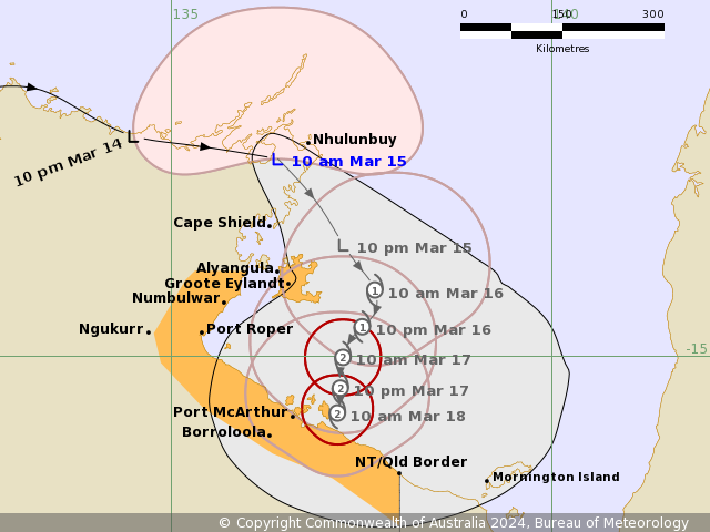
Details of Tropical Low at 9:30 am ACST:
Intensity: Tropical Low, sustained winds near the centre of 75
kilometres per hour with wind gusts to 100 kilometres per
hour.
Location: within 35 kilometres of 12.4 degrees South 136.4 degrees
East, estimated to be 45 kilometres west southwest of Nhulunbuy and
160 kilometres north of Alyangula.
Movement: east at 24 kilometres per hour.
The Advice has been updated to include Community Actions.
A tropical low, 09U, is currently located near Nhulunbuy, along
the northeastern Top End coast and is moving to the east southeast
towards the Gulf of Carpentaria.
The low is forecast to develop to a tropical cyclone Saturday
morning, to the east of Groote Eylandt. It is then forecast to move
slowly south towards the southwestern Gulf of Carpentaria coast. It
is most likely to cross the coast and weaken quickly early next
week.
Hazards:
Gales with DAMAGING WIND GUSTS of 110 km/h may develop over Groote
Eylandt during Saturday morning.
Gales with DAMAGING WIND GUSTS of 100 km/hr may extend further to
the Northern Territory coast between Alyangula to the Northern
Territory/Queensland border, including Borroloola, from as early as
Saturday evening, though more likely during Sunday. Destructive
winds gusts are also possible for the southwestern Gulf of
Carpentaria coast from late Sunday depending on how quickly the
system moves south.
HEAVY RAINFALL is already occurring over northeastern parts of the
Top End. This will increase into the weekend, with the heaviest
falls limited to coastal and island locations on Saturday before
reaching further inland into the Carpentaria forecast districts
into Sunday. Later in the weekend, INTENSE RAINFALL is possible,
especially about coastal parts of the Carpentaria districts.
ABNORMALLY HIGH TIDES near the path of the system could cause
MINOR FLOODING along the southwestern Gulf of Carpentaria coast
this weekend.
Recommended Action:
The Northern Territory Emergency Service advise:
- Prepare now
- Stay informed
- Monitor conditions
Current
Tropical Cyclones
15/Mar/2024 01:10 AM


