
Source: Bureau of Meteorology
Issued at 1:18 pm Friday, 16 February 2024.
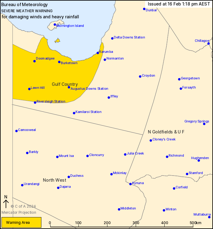
Heavy rainfall and damaging wind gusts across the Gulf
Country
Weather Situation: Tropical Cyclone Lincoln has formed in the
southern Gulf of Carpentaria. A coastal crossing is expected
between Port McArthur and the NT/Qld Border this afternoon. The
system is forecast to track towards the southwest through central
parts of the Northern Territory through the weekend, gradually
clearing widespread severe weather from the Gulf Country.
HEAVY RAINFALL which may lead to FLASH FLOODING is forecast for
the western Gulf Country today and through Saturday. Six-hourly
rainfall totals between 70 to 90 mm are likely. 24-hourly rainfall
totals between 100 to 150 mm are likely with falls up to 200 mm
near the low.
Strong winds averaging 50 to 60 km/h with DAMAGING WIND GUSTS
around 100 km/h are possible over western parts of the Gulf
Country.
Intense rainfall is no longer expected across the Gulf
Country.
A separate Tropical Cyclone Advice is also current. See
http://www.bom.gov.au/cyclone/index.shtml for more
information.
Flood Warnings are current for the area, please refer to
http://www.bom.gov.au/qld/warnings/ for more information.
Locations which may be affected include Doomadgee, Burketown,
Karumba, Augustus Downs Station, Westmoreland Station and Lawn
Hill.
Significant 24 hour rainfall totals to 9 am Friday AEST:
227 mm at Sweers Island
155 mm at Burketown Airport
Emergency services advise people to:
* Park your car undercover away from trees.
* Close doors and windows.
* Keep asthma medications close by. Storms and wind can trigger
asthma attacks.
* Charge mobile phones and power banks in case the power goes
out.
* Put your pets somewhere safe and make sure they can be
identified in case they get lost.
* Do not drive now unless you have to because conditions are
dangerous.
* Tell friends, family and neighbours in the area.
* Go inside a strong building now. Stay inside until the storm has
passed.
16/Feb/2024 03:24 AM


