
Source: Bureau of Meteorology
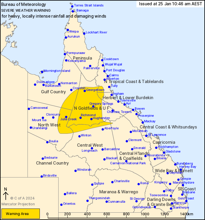
For people in Northern Goldfields and Upper Flinders and parts of
Gulf Country, North Tropical Coast and Tablelands, Herbert and
Lower Burdekin, North West, Central West and Central Highlands and
Coalfields Forecast Districts.
Issued at 10:46 am Thursday, 25 January 2024.
TROPICAL CYCLONE KIRRILY TO PRODUCE HEAVY, LOCALLY INTENSE
RAINFALL, WITH POSSIBLE DAMAGING WIND GUSTS OVER PARTS OF NORTHERN
QUEENSLAND.
Weather Situation: Tropical Cyclone Kirrily, category 2, is
currently located approximately 305km east northeast of Townsville.
It is forecast to track towards the coastline near Townsville
today, making landfall overnight tonight as a Category 2 system.
During Friday, the system is forecast to weaken to a tropical low
and continue tracking in a westerly trajectory across the northern
interior of the state.
HEAVY RAINFALL which may lead to FLASH FLOODING is forecast to
develop overnight tonight between the Northern Goldfields and Upper
Flinders district and the area inland of Tully and Ingham. HEAVY
RAINFALL is forecast to extend further inland towards Julia Creek
during Friday evening or early Saturday morning. 6-hourly rainfall
totals between 80 to 120 mm are likely, with 24-hourly totals up to
180 mm, particularly on the northern flank of the tropical
low.
Locally INTENSE RAINFALL which may lead to DANGEROUS AND
LIFE-THREATENING FLASH FLOODING is also possible on the northern
flank of the tropical low. Isolated 6-hourly totals between 150 to
180 mm are possible, with 24-hourly totals of around 250 mm also
possible. A separate Severe Thunderstorm Warning will be issued if
VERY DANGEROUS THUNDERSTORMS with INTENSE RAINFALL are
detected.
DAMAGING WINDS with peak gusts of around 90 km/h are possible from
Friday morning within the warning area.
Severe weather is expected to slowly extend westwards, subject to
the position and strength of the tropical low.
A separate Tropical Cyclone Advice is current for areas closer to
the coast. See http://www.bom.gov.au/cyclone/index.shtml for more
information.
A Flood Watch is also current for coastal and adjacent inland
catchments between Tully and Airlie Beach, and parts of the Central
West and Gulf catchments. See http://www.bom.gov.au/qld/warnings/
for more information.
Locations which may be affected include Georgetown, Hughenden,
Richmond, Julia Creek, Einasleigh and Stamford.
Emergency services advise people to:
* If you have children make sure they are with you or an adult you
trust.
* Park your car undercover away from trees.
* Close doors and windows.
* Keep asthma medications close by. Storms and wind can trigger
asthma attacks.
* Charge mobile phones and power banks in case the power goes
out.
* Put your pets somewhere safe and make sure they can be
identified in case they get lost.
* Do not drive now unless you have to because conditions are
dangerous.
* Tell friends, family and neighbours in the area.
* Go inside a strong building now. Stay inside until the storm has
passed.
25/Jan/2024 12:52 AM


