
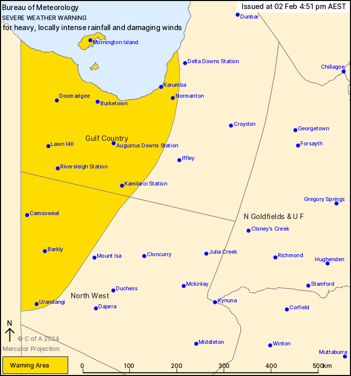
Source: Bureau of Meteorology
For people in parts of Gulf Country and North West Forecast
Districts.
Issued at 4:51 pm Friday, 2 February 2024.
HEAVY, LOCALLY INTENSE RAINFALL AND DAMAGING WINDS TO EXTEND SOUTH
THIS WEEKEND.
Weather situation: Ex-Tropical Cyclone Kirrily is currently
located around Doomadgee and is expected to remain slow-moving
about the western Gulf Country during this evening. The system will
begin to slowly track towards the Northern Territory border on
Saturday morning then move further south along or close to the
Queensland and Northern Territory border during through the
weekend. At this stage, the system is expected to move into the
Channel Country on Sunday, although some uncertainty remains with
its exact track.
HEAVY RAINFALL which may lead to FLASH FLOODING is expected in
parts of the Gulf Country, extending into the North West during
Saturday. Six-hourly rainfall totals between 90 and 150 mm are
likely, more likely near the Queensland and Northern Territory
border. 24-hourly totals between 150 and 250 mm with isolated falls
of 300mm are possible.
Locally INTENSE RAINFALL which may lead to DANGEROUS AND
LIFE-THREATENING FLASH FLOODING is also possible close to the low,
particularly on the southern and western sides of the system.
Isolated six-hourly totals between 150 and 200 mm are possible with
24-hourly totals exceeding 300 mm. A separate Severe Thunderstorm
Warning will be issued if VERY DANGEROUS THUNDERSTORMS with INTENSE
RAINFALL are detected.
DAMAGING WIND GUSTS of around 100 km/h are also possible across
the Gulf Country this evening, particularly in thunderstorms and
heavy showers, extending into the North West during Saturday.
A Flood Watch and several Flood Warnings are also current for the
Central West, Channel Country and Gulf of Carpentaria catchments.
See http://www.bom.gov.au/qld/warnings/ for more information.
Locations which may be affected include Mornington Island,
Normanton, Doomadgee, Camooweal, Burketown and Karumba.
Latest significant observations:
332 mm was observed at Westmoreland Station in 24 hours to 9 am
Friday.
150 mm was observed at Mornington Island Airport in 24 hours to 9
am Friday.
Gale force winds with a peak wind gust of 94 km/h recorded at
Mornington Island Airport at 7:35 am Friday.
Emergency services advise people to:
* If you have children make sure they are with you or an adult you
trust.
* Park your car undercover away from trees.
* Close doors and windows.
* Keep asthma medications close by. Storms and wind can trigger
asthma attacks.
* Charge mobile phones and power banks in case the power goes
out.
* Put your pets somewhere safe and make sure they can be
identified in case they get lost.
* Do not drive now unless you have to because conditions are
dangerous.
* Tell friends, family and neighbours in the area.
* Go inside a strong building now. Stay inside until the storm has
passed.
02/Feb/2024 06:58 AM


