
Source: Bureau of Meteorology
Issued at 8:58 pm EST on Thursday 25 January 2024
Headline:
Severe Tropical Cyclone Kirrily is crossing the coast just
northwest of Townsville.
Areas Affected:
Warning Zone
Innisfail to Bowen, not including Bowen, including Townsville and
extending inland to Charters Towers.
Watch Zone
None.
Cancelled Zone
Mackay to Bowen.
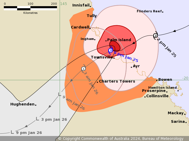
Details of Severe Tropical Cyclone Kirrily at 9:00 pm AEST:
Intensity: Category 3, sustained winds near the centre of 120
kilometres per hour with wind gusts to 165 kilometres per
hour.
Location: within 20 kilometres of 19.0 degrees South 146.7 degrees
East, estimated to be 30 kilometres north northwest of Townsville
and 180 kilometres south southeast of Innisfail.
Movement: west southwest at 25 kilometres per hour.
Severe Tropical Cyclone Kirrily is tracking generally west
southwest and is crossing just to the northwest of Townsville as a
Category 3 system. Kirrily will then weaken as it moves
inland.
From Friday, the system is likely to track further inland as a
tropical low, resulting in heavy to intense rain and possible
damaging winds to parts of the northern interior and western
Queensland.
Hazards:
GALES with DAMAGING WIND GUSTS to 120 km/h are occurring on the
coast and offshore islands between Cardwell and Bowen, including
Townsville. GALES with DAMAGING WIND GUSTS to 120 km/h may extend
north between Cardwell to Innisfail tonight if the system takes a
track further north.
DESTRUCTIVE WIND GUSTS to 155 km/h are occurring about coastal and
island communities between Ayr and Cardwell.
VERY DESTRUCTIVE WIND GUSTS to 170 km/hr may occur near the centre
as Kirrily crosses the coast.
GALES with DAMAGING WIND GUSTS to 90 km/h are expected to extend
to inland areas including Charters Towers tonight and into Friday
morning.
HEAVY RAINFALL which may lead to FLASH FLOODING has developed
about coastal areas and nearby inland between Tully and Bowen and
will spread further inland overnight tonight and during Friday.
INTENSE RAINFALL which may lead to DANGEROUS AND LIFE THREATENING
FLASH FLOODING is possible near the track of the system. Flood
watches and warnings are current for these areas.
During Friday, the system is expected to become a tropical low and
HEAVY RAINFALL is forecast to develop across the northern interior
and western Queensland into the weekend as the system tracks
inland. A Severe Weather Warning is also current for inland
areas.
As the system approaches and crosses the coast, a STORM TIDE is
expected between Townsville and Alva Beach. Large waves may produce
minor flooding along the foreshore. People living in areas likely
to be affected by this flooding should take measures to protect
their property as much as possible and be prepared to help their
neighbours.
Recommended Action:
People between Innisfail to Cardwell, Ayr to Bowen and extending
inland to Charters Towers, should remain inside until the cyclone
has passed and listen to the next advice.
- For cyclone preparedness and safety advice, visit Queensland's
Disaster Management Services website
(www.disaster.qld.gov.au)
- For emergency assistance call the Queensland State Emergency
Service (SES) on 132 500 (for assistance with storm damage, rising
flood water, fallen trees on buildings or roof damage).
People between Cardwell and Ayr, including Townsville and Ingham
should complete preparations quickly and be prepared to shelter in
a safe place.
- If you choose to take shelter away from your home, stay COVID-19
safe and pack a mask and hand sanitiser (if you have them).
- Boats and outside property should be secured.
- For cyclone preparedness and safety advice, visit Queensland's
Disaster Management Services website
(www.disaster.qld.gov.au)
- For emergency assistance call the Queensland State Emergency
Service (SES) on 132 500 (for assistance with storm damage, rising
flood water, fallen trees on buildings or roof damage).
- People in the path of the dangerous cyclone should stay calm and
remain in a secure shelter while the destructive or very
destructive winds continue.
- Do not venture outside if you find yourself in the eye of the
cyclone - destructive or very destructive winds from a different
direction could resume at any time.
- Heed the advice and follow the instructions of Police, Emergency
Services personnel and local authorities.
Current
Tropical Cyclones
25/Jan/2024 11:18 AM


