
Source: Bureau of Meteorology
Issued at 7:54 am EST on Monday 22 January 2024
Headline:
Tropical cyclone impact likely on the Queensland coast from
Wednesday.
Areas Affected:
Warning Zone
None.
Watch Zone
Ayr to St Lawrence, including Mackay and the Whitsunday
Islands.
Cancelled Zone
None.
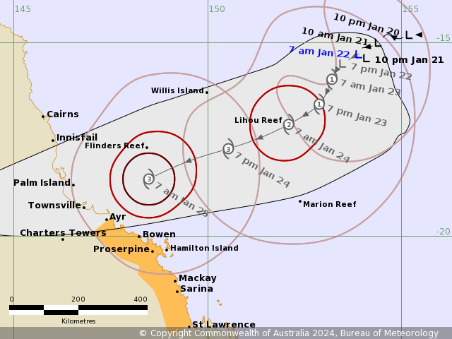
Details of Tropical Low at 7:00 am AEST [6:30 am ACST]:
Intensity: Tropical Low, sustained winds near the centre of 55
kilometres per hour with wind gusts to 85 kilometres per
hour.
Location: within 55 kilometres of 15.3 degrees South 153.9 degrees
East, estimated to be 435 kilometres east northeast of Willis
Island and 880 kilometres east northeast of Townsville.
Movement: slow moving.
A tropical low (05U) is slow moving in the central Coral Sea and
is likely to become a tropical cyclone during Tuesday. The low is
forecast to begin moving to the southwest later today, towards the
east Queensland coast.
The system is forecast to cross the coast, most likely between
Innisfail and Airlie Beach and during Thursday. From Friday the
system is forecast to move inland and further south.
Hazards:
GALES with DAMAGING WIND GUSTS to 120 km/h may develop about
coastal and island communities between Ayr and St Lawrence from as
early as Wednesday morning and extend to adjacent inland areas
later on Wednesday.
HEAVY RAINFALL which may lead to FLASH FLOODING may develop about
coastal areas between Ayr and St Lawrence during Wednesday before
spreading to adjacent inland areas and possibly further north to
the North Tropical Coast during Thursday and into Friday.
From Friday, the system is expected to become an inland rain
depression and HEAVY RAINFALL may develop across central and
southern inland, as well as southeast Queensland over the weekend
as the system tracks south.
As the system approaches the coast, a STORM TIDE is possible
between Ayr and St Lawrence. Large waves may produce minor flooding
along the foreshore.
Recommended Action:
People between Ayr to St Lawrence, including Mackay and the
Whitsunday Islands, should consider what action they will need to
take if the cyclone threat increases.
- Information is available from your local government
- For cyclone preparedness and safety advice, visit Queensland's
Disaster Management Services website
(www.disaster.qld.gov.au)
- For emergency assistance call the Queensland State Emergency
Service (SES) on 132 500 (for assistance with storm damage, rising
flood water, fallen trees on buildings or roof damage).
Current
Tropical Cyclones
21/Jan/2024 10:06 PM


