
Source: Bureau of Meteorology
Issued at 12:58 pm WST on Wednesday 6 March 2024
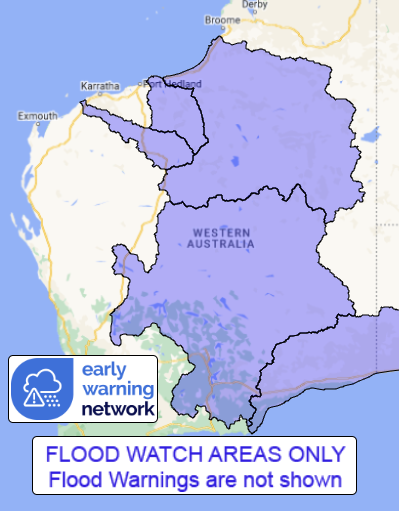
Flood Watch Number: 5
ISOLATED FLOODING POSSIBLE IN THE SALT LAKE AND NULLARBOR DISTRICT
RIVERS, SANDY DESERT AND PARTS OF THE PILBARA COAST RIVERS DURING
WEDNESDAY
Heavy rain with showers and thunderstorms is forecast across the
Flood Watch area over the next few days.
Catchments in the Flood Watch area are becoming more wet with
recent rainfall.
Rainfall totals of up to 77 mm were recorded across the Flood
Watch area in the 24 hours to 9:00 am Wednesday. River level rises
have been observed at some locations within the Flood Watch
area.
Widespread daily rainfall totals between 30 - 60 mm, with isolated
totals up to about 90 mm are forecast for Wednesday and Thursday.
Further rain with less daily totals is forecast from Friday
onwards.
Significant river, creek, and stream rises are likely with heavy
rainfall, with flooding and overland inundation possible across
parts of the Flood Watch area.
Many roads, and possibly primary and secondary highways may be
affected. Some communities and homesteads may become isolated.
Check road conditions before travelling.
Catchments likely to be affected include:
De Grey River
Fortescue River
Nullarbor District Rivers
Salt Lakes District Rivers
Sandy Desert
This flood watch is available by dialling 1300 659 213. For more
information on the Flood Watch Service visit
http://www.bom.gov.au/water/floods/floodWarningServices.shtml
Flood Safety Advice:
DFES advises people and communities to be aware that flooding is
possible and be prepared to relocate equipment and livestock. Watch
water levels. Travellers need to be aware that road conditions may
be adversely affected and travel plans may need to be reconsidered.
Do not drive into water of unknown depth and velocity.
Community information is available from DFES at
www.emergency.wa.gov.au/
Current river levels are available from Department of Water and
Environmental Regulation at
www.water.wa.gov.au/maps-and-data/monitoring/river-level-monitoring
Rainfall and River
Conditions Map
06/Mar/2024 05:14 AM


