
Source: Bureau of Meteorology
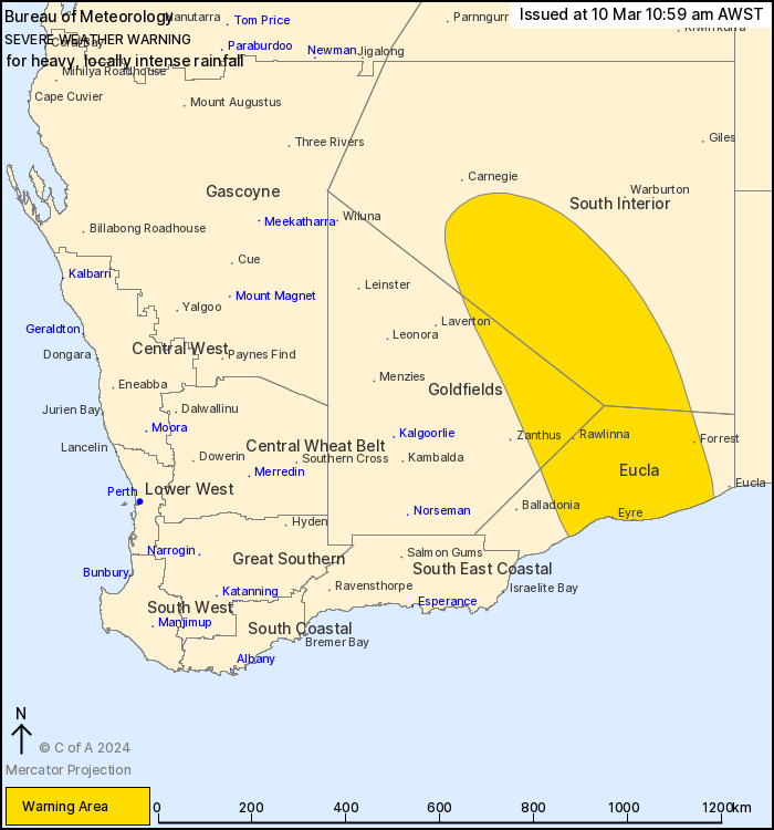
For people in Eucla and parts of Goldfields and South Interior
districts.
Issued at 10:59 am Sunday, 10 March 2024.
HEAVY TO LOCALLY INTENSE RAINFALL OCCURRING ABOUT SOUTHEASTERN
WESTERN AUSTRALIA TODAY AND INTO MONDAY.
Weather Situation: A near-stationary trough over southeastern
Western Australia will remain in the area for the next few days. An
extremely moist airmass drawn down from the tropics will interact
with this trough to produce a broad band of heavy rainfall, with
embedded thunderstorms capable of locally intense falls.
HEAVY RAINFALL which may lead to FLASH FLOODING is forecast for
parts of the eastern Goldfields, Eucla and southern South Interior
today and into Monday. Six-hourly rainfall totals between 30 to 60
mm are likely, with 24-hour totals of 50 to 90 mm also
likely.
Locally INTENSE RAINFALL which may lead to DANGEROUS AND
LIFE-THREATENING FLASH FLOODING is also possible with embedded
thunderstorm activity in the rain band, more likely during the
overnight period. Isolated six-hourly totals of around 80 mm are
possible, with 24-hour totals of 120 to 150 mm also possible. A
separate Severe Thunderstorm Warning will be issued if very
dangerous thunderstorms with intense rainfall are detected.
Heavy rainfall is likely to persist with this system during Monday
and into Tuesday as the weather pattern is very slow moving. This
is not typical weather for southeastern Western Australia.
A Flood Watch is current for catchments in the southeast. Please
refer to http://www.bom.gov.au/wa/warnings/ for more
information.
Locations which may be affected include Cocklebiddy, Eyre, Forrest
and Rawlinna.
Eyre reported 157mm in 24 hours to 9:00am Sunday.
Tropicana reported 126mm in 24 hours to 9:00am Sunday
Zanthus recorded 101 mm in 24 hours to 9:00 am Sunday
Gruyere Airport reported 45.8mm in 6 hours to 1:00am Sunday.
Laverton Airport reported 57mm in 6 hours to 2:30pm
Saturday.
The Department of Fire and Emergency Services advises that people
should:
* If outside find safe shelter away from trees, power lines, storm
water drains and streams.
* Close your curtains and blinds, and stay inside away from
windows.
* Unplug electrical appliances and do not use land line telephones
if there is lightning.
* If boating, swimming or surfing leave the water.
* Be alert and watch for hazards on the road such as fallen power
lines and loose debris.
* Keep away from flooded drains, rivers, streams and
waterways.
* Be careful of fallen trees, damaged buildings and debris.
* Be careful of fallen power lines. They are dangerous and should
always be treated as live.
* Assess your home, car and property for damage.
* If damage has occurred take photos and contact your insurance
company to organise permanent repairs.
* If your home or property has significant damage, like a badly
damaged roof or flooding, call the SES on 132 500.
10/Mar/2024 03:04 AM


