
Source: Bureau of Meteorology
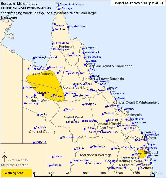
For people in parts of Gulf Country, Northern Goldfields and Upper
Flinders, North West, Wide Bay and Burnett, Southeast Coast,
Central West and Darling Downs and Granite Belt Forecast
Districts.
Issued at 5:00 pm Sunday, 2 November 2025.
SEVERE THUNDERSTORMS WITH POSSIBLE INTENSE RAINFALL THROUGH PARTS
OF SOUTHEAST QUEENSLAND.
Weather Situation: Moisture and deep instability along and to the
east of a surface trough is promoting the development of severe
thunderstorm activity this afternoon.
Severe thunderstorms are likely to produce damaging winds over the
next several hours in parts of the Gulf Country, Northern
Goldfields and Upper Flinders, North West and Central West
districts. Locations which may be affected include Cloncurry, Julia
Creek, Kamilaroi Station, Augustus Downs Station, Riversleigh
Station, Donors Hill Station, Gregory Downs Station, Iffley and
Cloney's Creek.
VERY DANGEROUS THUNDERSTORMS are likely to produce heavy, locally
intense rainfall that may lead to dangerous and life-threatening
flash flooding, damaging winds and large hailstones over the next
several hours in parts of the Wide Bay and Burnett, Southeast Coast
and Darling Downs and Granite Belt districts. Locations which may
be affected include Lowood, Nanango, Esk, Kilcoy, Woodford, Crows
Nest and Yarraman.
104 km/h wind gust was recorded at Cloncurry Airport at 03:23
pm.
Emergency services advise people to:
* If you have children make sure they are with you or an adult you
trust.
* Park your car undercover away from trees.
* Close doors and windows.
* Keep asthma medications close by. Storms and wind can trigger
asthma attacks.
* Charge mobile phones and power banks in case the power goes
out.
* Put your pets somewhere safe and make sure they can be
identified in case they get lost.
* Do not drive now unless you have to because conditions are
dangerous.
* Tell friends, family and neighbours in the area.
* Go inside a strong building now. Stay inside until the storm has
passed.
02/Nov/2025 07:08 AM


