
Source: Bureau of Meteorology
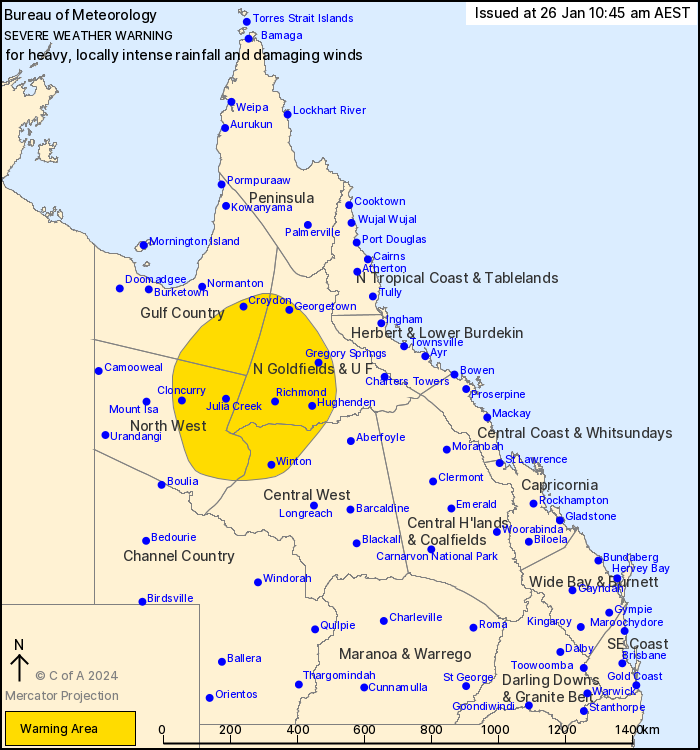
For people in parts of Gulf Country, Northern Goldfields and Upper
Flinders, North West and Central West Forecast Districts.
Issued at 10:45 am Friday, 26 January 2024.
EX-TROPICAL CYCLONE KIRRILY TO PRODUCE HEAVY, LOCALLY INTENSE
RAINFALL, WITH POSSIBLE DAMAGING WINDS OVER PARTS OF NORTHERN
QUEENSLAND.
Weather Situation: Ex-Tropical Cyclone Kirrily is currently
located about the southern Northern Goldfields and Upper Flinders
district. It is forecast to continue tracking in a southwesterly
trajectory across the northern interior of the state, before taking
a more westerly track towards the Northern Territory border during
Saturday.
HEAVY RAINFALL which may lead to FLASH FLOODING is occurring in
the northern parts of the Northern Goldfields and Upper Flinders
and southeastern Gulf Country districts. HEAVY RAINFALL is forecast
to extend further inland towards the northwestern Central West and
eastern North West districts overnight, persisting through
Saturday. 6-hourly rainfall totals between 70 to 110 mm are likely,
with 24-hourly totals up to 130 mm.
Locally INTENSE RAINFALL which may lead to DANGEROUS AND
LIFE-THREATENING FLASH FLOODING is possible from early Saturday
morning for areas between Winton, Richmond and Cloncurry. Isolated
6-hourly totals between 120 to 150 mm are possible, with 24-hourly
totals of around 180 mm possible. A separate Severe Thunderstorm
Warning will be issued if VERY DANGEROUS THUNDERSTORMS with INTENSE
RAINFALL are detected.
DAMAGING WINDS with peak gusts of around 90 km/h are possible
within the warning area.
Severe weather is expected to slowly extend westwards, subject to
the position and strength of the tropical low.
A Flood Watch is also current for coastal and adjacent inland
catchments between Tully and Airlie Beach, and parts of the Central
West and Gulf catchments. See http://www.bom.gov.au/qld/warnings/
for more information.
Locations which may be affected include Georgetown, Hughenden,
Richmond, Julia Creek, Einasleigh and Stamford.
163 mm of rainfall recorded in the 12 hours to 6:12 am at Mt
Garnett.
147 mm of rainfall recorded in the 24 hours to 7:00 am at Crooks
Dam.
145 mm of rainfall recorded in the 6 hours to 12:33 am at Running
River (Hidden Valley).
129 mm of rainfall recorded in the 12 hours to 7:08 am at Upper
Poison.
97 mm of rainfall recorded in the 6 hours to 3:00 am at Mt
Fullstop.
96 mm of rainfall recorded in the 6 hours to 10:11 am at Dutton
River.
69.6 mm of rainfall recorded in the 1 hour to 9:35 am at Hughenden
Airport.
Emergency services advise people to:
* If you have children make sure they are with you or an adult you
trust.
* Park your car undercover away from trees.
* Close doors and windows.
* Keep asthma medications close by. Storms and wind can trigger
asthma attacks.
* Charge mobile phones and power banks in case the power goes
out.
* Put your pets somewhere safe and make sure they can be
identified in case they get lost.
* Do not drive now unless you have to because conditions are
dangerous.
* Tell friends, family and neighbours in the area.
* Go inside a strong building now. Stay inside until the storm has
passed.
26/Jan/2024 12:56 AM


