
Source: Bureau of Meteorology
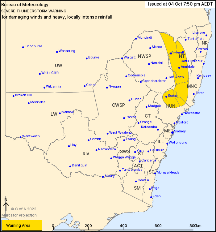
For people in parts of Mid North Coast, Hunter, North West Slopes
and Plains and Northern Tablelands Forecast Districts.
Issued at 7:50 pm Wednesday, 4 October 2023.
Severe thunderstorms continuing about central and northern
NSW.
Weather Situation: A vigorous cold front and associated upper
trough will sweep across the state today, resulting in the
development of fast-moving severe thunderstorms capable of
producing damaging wind gusts, with heavy rainfall possible through
parts of the Upper Hunter.
Severe thunderstorms are likely to produce damaging winds over the
next several hours in parts of the Mid North Coast, Hunter, North
West Slopes and Plains and Northern Tablelands districts. Locations
which may be affected include Armidale, Glen Innes, Inverell,
Tingha, Bundarra and Ashford.
Severe thunderstorms are likely to produce heavy, locally intense
rainfall that may lead to dangerous and life-threatening flash
flooding over the next several hours in parts of the Hunter, Mid
North Coast and North West Slopes and Plains districts. Locations
which may be affected include Scone, Barrington Tops, Singleton,
Muswellbrook and Dungog.
101 km/h wind gust observed at Murrurundi Gap at 06:05 pm.
98 km/h wind gust observed at Scone at 06:13 pm.
70.6 mm of rainfall recorded at Yarrandi Bridge in the 1 hour to
07:45 pm.
52.8 mm of rainfall recorded at Aberdeen in the 1 hour to 07:45
pm.
The State Emergency Service advises that people should:
* Move your car under cover or away from trees.
* Secure or put away loose items around your house, yard and
balcony.
* Keep at least 8 metres away from fallen power lines or objects
that may be energised, such as fences.
* Report fallen power lines to either Ausgrid (131 388), Endeavour
Energy (131 003), Essential Energy (132 080) or Evoenergy (131 093)
as shown on your power bill.
* Trees that have been damaged by fire are likely to be more
unstable and more likely to fall.
* Keep clear of creeks and storm drains.
* Don't walk, ride your bike or drive through flood water.
* If you are trapped by flash flooding, seek refuge in the highest
available place and ring 000 if you need rescue.
* Be aware that run-off from rainfall in fire affected areas may
behave differently and be more rapid. It may also contain debris
such as ash, soil, trees and rocks.
* After bushfires, heavy rain and the loss of foliage can make the
ground soft and heavy, leading to a greater chance of
landslides.
* Unplug computers and appliances.
* Avoid using the phone during the storm.
* Stay indoors away from windows, and keep children and pets
indoors as well.
* Stay vigilant and monitor conditions. Note that the landscape
may have changed following bushfires.
* For emergency help in floods and storms, ring the SES (NSW and
ACT) on 132 500.
04/Oct/2023 08:56 AM


