
Source: Bureau of Meteorology
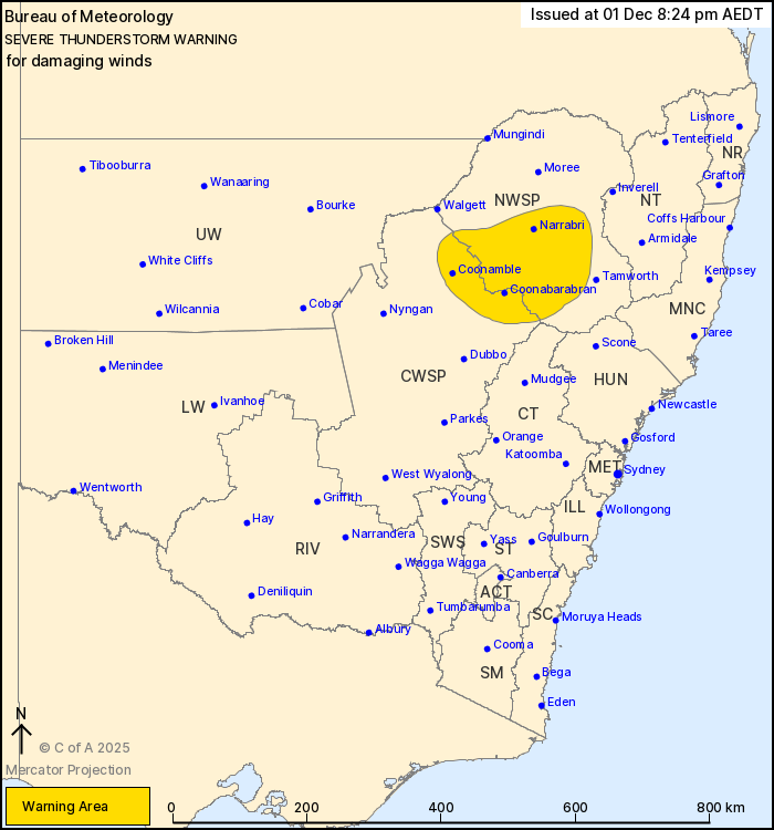
For people in parts of North West Slopes and Plains and Central
West Slopes and Plains Forecast Districts.
Issued at 8:24 pm Monday, 1 December 2025.
Localised damaging wind gusts in the north
Weather Situation: A cold pool moving over inland New South Wales
continues to trigger isolated showers and thunderstorms that are
generating some localised damaging wind gusts this evening.
Severe thunderstorms and showers are likely to produce isolated
damaging winds in the warning area over the next several hours.
Locations which may be affected include Narrabri, Coonabarabran,
Coonamble, Gunnedah, Wee Waa and Barraba.
111 km/h wind gust was recorded at Coonamble Airport at 8:13
pm
94 km/h wind gust was recorded at Condobolin at 3:30 pm
The State Emergency Service advises that people should:
* Move your car under cover or away from trees.
* Secure or put away loose items around your house, yard and
balcony.
* Keep at least 8 metres away from fallen power lines or objects
that may be energised, such as fences.
* Report fallen power lines to either Ausgrid (131 388), Endeavour
Energy (131 003), Essential Energy (132 080) or Evoenergy (131 093)
as shown on your power bill.
* Trees that have been damaged by fire are likely to be more
unstable and more likely to fall.
* Unplug computers and appliances.
* Avoid using the phone during the storm.
* Stay indoors away from windows, and keep children and pets
indoors as well.
* Stay vigilant and monitor conditions. Note that the landscape
may have changed following bushfires.
* For emergency help in floods and storms, ring the SES (NSW and
ACT) on 132 500.
01/Dec/2025 09:29 AM


