
Source: Bureau of Meteorology
For people in parts of Northern Rivers, Mid North Coast, North
West Slopes and Plains and Northern Tablelands Forecast
Districts.
Issued at 12:35 am Saturday, 11 October 2025.
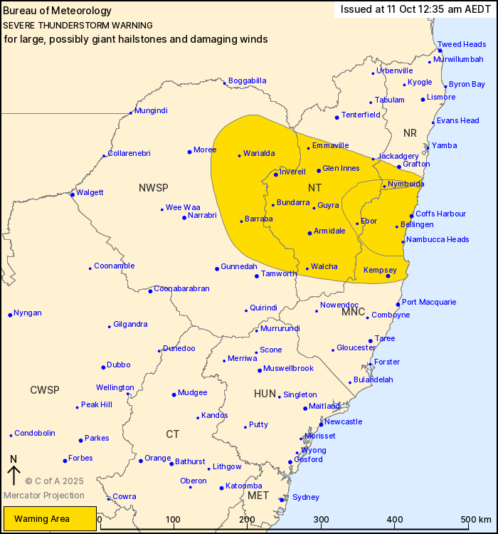
VERY DANGEROUS THUNDERSTORMS WITH GIANT HAIL OVER THE MID NORTH
COAST.
Weather Situation: A trough of low pressure over the northeast of
the state combines with a relatively warm and humid airmass to
produce severe thunderstorms overnight.
VERY DANGEROUS THUNDERSTORMS are likely to produce LARGE, POSSIBLY
GIANT HAILSTONES and damaging wind gusts over the next several
hours in parts of the Northern Rivers, Mid North Coast and Northern
Tablelands districts. Locations which may be affected include Coffs
Harbour, Nymboida, Bellingen, Ebor, Nambucca Heads and
Woolgoolga.
Severe thunderstorms are likely to produce large hailstones and
damaging wind gusts over the next several hours in parts of the
Northern Rivers, Mid North Coast, North West Slopes and Plains and
Northern Tablelands districts. Locations which may be affected
include Coffs Harbour, Armidale, Kempsey, Glen Innes, Inverell and
Jackadgery.
100 km/h wind gust was recorded at Glen Innes at 11:22 pm
AEDT.
The State Emergency Service advises that people should:
* Move your car under cover or away from trees.
* Secure or put away loose items around your house, yard and
balcony.
* Keep at least 8 metres away from fallen power lines or objects
that may be energised, such as fences.
* Report fallen power lines to either Ausgrid (131 388), Endeavour
Energy (131 003), Essential Energy (132 080) or Evoenergy (131 093)
as shown on your power bill.
* Trees that have been damaged by fire are likely to be more
unstable and more likely to fall.
* Unplug computers and appliances.
* Avoid using the phone during the storm.
* Stay indoors away from windows, and keep children and pets
indoors as well.
* Stay vigilant and monitor conditions. Note that the landscape
may have changed following bushfires.
* For emergency help in floods and storms, ring the SES (NSW and
ACT) on 132 500.
10/Oct/2025 01:45 PM


