
Source: Bureau of Meteorology
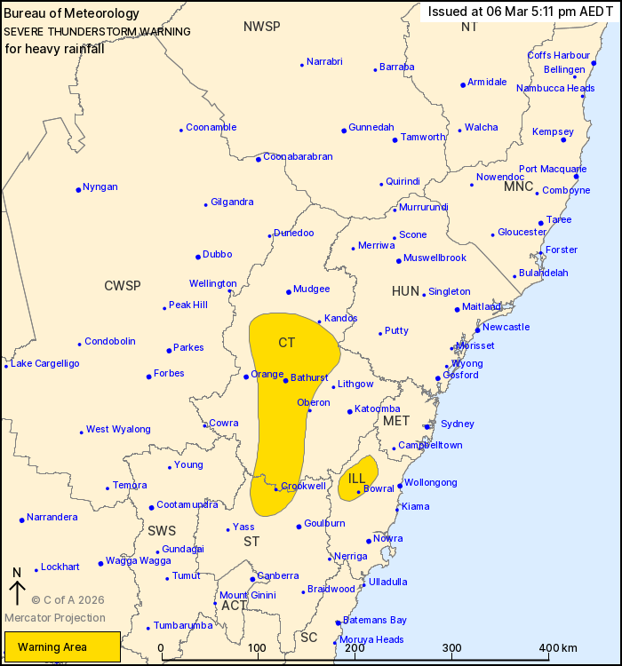
For people in parts of Illawarra, Central Tablelands, Southern
Tablelands and Hunter Forecast Districts.
Issued at 5:11 pm Friday, 6 March 2026.
Isolated heavy falls continuing over the central ranges and
tablelands.
Weather Situation: slow-moving thunderstorms with heavy rainfall
have been detected along a trough lying over the ranges. These
thunderstorms are expected to ease throughout the evening.
Severe thunderstorms are likely to produce heavy rainfall that may
lead to flash flooding in the warning area over the next several
hours. Locations which may be affected include Bowral, Bathurst,
Crookwell, Capertee, Trunkey Creek and Hill End.
The State Emergency Service advises that people should:
* Keep clear of creeks and storm drains.
* Don't walk, ride your bike or drive through flood water.
* If you are trapped by flash flooding, seek refuge in the highest
available place and ring 000 if you need rescue.
* Stay indoors away from windows, and keep children and pets
indoors as well.
For emergency help in flood and storms, ring the SES on 132
500.
Stay updated on the Hazards Near Me NSW app or the ACT ESA website
(https://esa.act.gov.au).
06/Mar/2026 06:19 AM

