
Source: Bureau of Meteorology
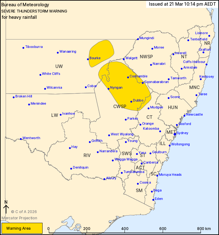
For people in parts of Central Tablelands, Central West Slopes and
Plains, Upper Western and North West Slopes and Plains Forecast
Districts.
Issued at 10:14 pm Saturday, 21 March 2026.
Severe thunderstorm complexes with heavy rainfall continuing this
evening over Central West Slopes and Plains and Upper
Western.
Weather Situation: An upper-level trough located over the central
parts of the state is driving persistent thunderstorm activity over
central northern parts of the state this evening.
Severe thunderstorms are likely to produce heavy rainfall that may
lead to flash flooding in the warning area over the next several
hours. Locations which may be affected include Dubbo,
Coonabarabran, Coonamble, Nyngan, Wellington and Brewarrina.
Severe thunderstorms are no longer occurring in the Southern
Tablelands, South West Slopes, Riverina, Snowy Mountains,
Australian Capital Territory and Northern Tablelands districts and
the warning for these districts is CANCELLED.
49.0 MM WAS RECORDED AT BORENORE CREEK (NORTH OF ORANGE) IN THE 30
MINUTES TO 6:34 PM.
The State Emergency Service advises that people should:
* Keep clear of creeks and storm drains.
* Don't walk, ride your bike or drive through flood water.
* If you are trapped by flash flooding, seek refuge in the highest
available place and ring 000 if you need rescue.
* Stay indoors away from windows, and keep children and pets
indoors as well.
For emergency help in flood and storms, ring the SES on 132
500.
Stay updated on the Hazards Near Me NSW app or the ACT ESA website
(https://esa.act.gov.au).
21/Mar/2026 11:18 AM

