
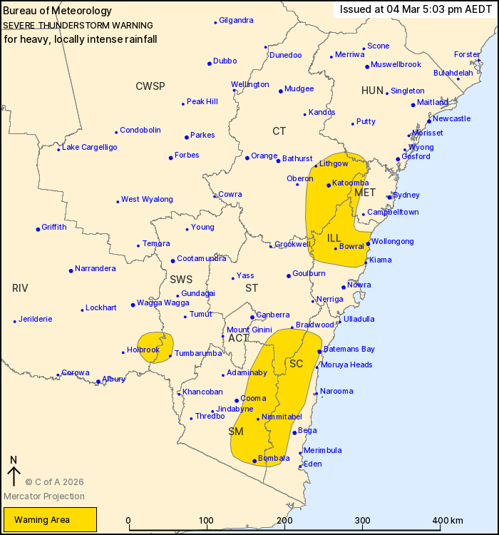
Source: Bureau of Meteorology
For people in parts of Metropolitan, Illawarra, South Coast,
Central Tablelands, Southern Tablelands, South West Slopes, Snowy
Mountains, Hunter and Riverina Forecast Districts.
Issued at 5:03 pm Wednesday, 4 March 2026.
VERY DANGEROUS THUNDERSTORMS WITH HEAVY, LOCALLY INTENSE RAINFALL
WITH SLOW MOVING THUNDERSTORMS OVER PARTS OF THE SOUTH COAST,
SOUTHERN TABLELANDS AND SNOW MOUNTAINS.
Weather Situation: A trough over southern New South Wales is
generating slow moving thunderstorms with heavy, LOCALLY INTENSE
RAINFALL about southern and central parts of the state.
VERY DANGEROUS THUNDERSTORMS are likely to produce heavy, locally
intense rainfall that may lead to dangerous and life-threatening
flash flooding over the next several hours in parts of the South
Coast, Southern Tablelands and Snowy Mountains districts. Locations
which may be affected include Batemans Bay, Bombala, Nimmitabel,
Araluen and Captains Flat.
Severe thunderstorms are likely to produce heavy rainfall that may
lead to flash flooding over the next several hours in parts of the
Metropolitan, Illawarra, Central Tablelands, South West Slopes,
Hunter, Southern Tablelands and Riverina districts. Locations which
may be affected include Wollongong, Bowral, Katoomba, Tumbarumba,
Lithgow and Penrith.
65 MM WAS RECORDED AT BENDETHERA IN THE 60 MINUTES TO 4:59
PM.
39 mm was recorded at Bowral in the 1 hour to 4:15 pm.
The State Emergency Service advises that people should:
* Keep clear of creeks and storm drains.
* Don't walk, ride your bike or drive through flood water.
* If you are trapped by flash flooding, seek refuge in the highest
available place and ring 000 if you need rescue.
* Stay indoors away from windows, and keep children and pets
indoors as well.
For emergency help in flood and storms, ring the SES on 132
500.
Stay updated on the Hazards Near Me NSW app or the ACT ESA website
(https://esa.act.gov.au).
04/Mar/2026 06:08 AM

