
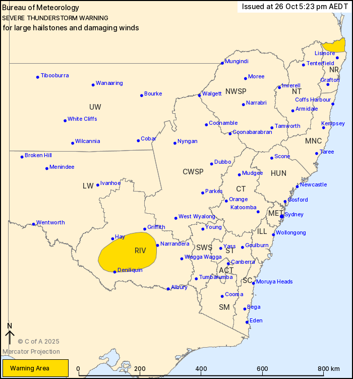
Source: Bureau of Meteorology
For people in parts of Northern Rivers, Riverina and Northern
Tablelands Forecast Districts.
Issued at 5:23 pm Sunday, 26 October 2025.
Severe thunderstorms continue across the Riverina, developing in
the northeast.
Weather Situation: A cold front sweeping across the south of the
state is interacting with a moist and unstable atmosphere to
generate severe thunderstorms this afternoon. Severe thunderstorms
are also developing near the Queensland border in a moist and
unstable atmosphere.
Severe thunderstorms are likely to produce large hailstones and
damaging winds in the warning area over the next several hours.
Locations which may be affected include Deniliquin, Tweed Heads,
Murwillumbah, Mullumbimby, Brunswick Heads and Hastings
Point.
The State Emergency Service advises that people should:
* Move your car under cover or away from trees.
* Secure or put away loose items around your house, yard and
balcony.
* Keep at least 8 metres away from fallen power lines or objects
that may be energised, such as fences.
* Report fallen power lines to either Ausgrid (131 388), Endeavour
Energy (131 003), Essential Energy (132 080) or Evoenergy (131 093)
as shown on your power bill.
* Trees that have been damaged by fire are likely to be more
unstable and more likely to fall.
* Unplug computers and appliances.
* Avoid using the phone during the storm.
* Stay indoors away from windows, and keep children and pets
indoors as well.
* Stay vigilant and monitor conditions. Note that the landscape
may have changed following bushfires.
* For emergency help in floods and storms, ring the SES (NSW and
ACT) on 132 500.
26/Oct/2025 06:28 AM


