
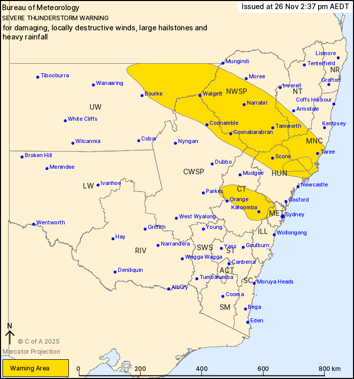
Source: Bureau of Meteorology
For people in North West Slopes and Plains and parts of Mid North
Coast, Hunter, Metropolitan, Central Tablelands, Central West
Slopes and Plains, Upper Western, Northern Tablelands and Illawarra
Forecast Districts.
Issued at 2:37 pm Wednesday, 26 November 2025.
VERY DANGEROUS THUNDERSTORMS CONTINUE SOUTHEAST OF SCONE TRACKING
TO THE NORTHEAST, DESTRUCTIVE WINDS POSSIBLE.
Weather Situation: A cold front moving through NSW combines with
an upper-level trough and an unstable airmass to produce severe
thunderstorms this afternoon and evening.
Severe thunderstorms are likely to produce damaging winds and
large hailstones over the next several hours in the North West
Slopes and Plains and parts of the Mid North Coast, Hunter,
Metropolitan, Central Tablelands, Central West Slopes and Plains,
Upper Western, Northern Tablelands and Illawarra districts.
Locations which may be affected include Taree, Tamworth, Scone,
Katoomba, Narrabri and Walgett.
VERY DANGEROUS THUNDERSTORMS are likely to produce damaging,
locally destructive winds, large hailstones and heavy rainfall that
may lead to flash flooding over the next several hours in parts of
the Mid North Coast and Hunter districts. Locations which may be
affected include Dungog.
119 km/h wind gust recorded at Nobby's Head at 02:12 pm.
100 km/h wind gust recorded at Maitland Airport at 02:03 pm.
106 km/h wind gust recorded at Merriwa at 01:52 pm.
109 km/h wind gust recorded at Dubbo at 12:25 pm.
111 km/h wind gust recorded at Trangie at 12:01 pm.
110 km/h wind gust recorded at Orange at 11:52 am.
98 km/h wind gust recorded at Parkes at 11:02 am.
The State Emergency Service advises that people should:
* Move your car under cover or away from trees.
* Secure or put away loose items around your house, yard and
balcony.
* Keep at least 8 metres away from fallen power lines or objects
that may be energised, such as fences.
* Report fallen power lines to either Ausgrid (131 388), Endeavour
Energy (131 003), Essential Energy (132 080) or Evoenergy (131 093)
as shown on your power bill.
* Trees that have been damaged by fire are likely to be more
unstable and more likely to fall.
* Keep clear of creeks and storm drains.
* Don't walk, ride your bike or drive through flood water.
* If you are trapped by flash flooding, seek refuge in the highest
available place and ring 000 if you need rescue.
* Be aware that run-off from rainfall in fire affected areas may
behave differently and be more rapid. It may also contain debris
such as ash, soil, trees and rocks.
* After bushfires, heavy rain and the loss of foliage can make the
ground soft and heavy, leading to a greater chance of
landslides.
* Unplug computers and appliances.
* Avoid using the phone during the storm.
* Stay indoors away from windows, and keep children and pets
indoors as well.
26/Nov/2025 03:54 AM

