
Source: Bureau of Meteorology
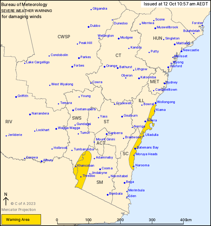
For people in parts of Illawarra, South Coast, South West Slopes
and Snowy Mountains Forecast Districts.
Issued at 10:57 am Thursday, 12 October 2023.
Damaging winds continuing over alpine areas until thursday
afternoon, and developing over the southern coastal fringe in the
late afternoon.
Weather Situation: Strong north to northwesterly winds in alpine
areas will continue ahead a cold front that will move eastwards
across southern NSW today, with winds easing following the passage
of the front during the afternoon. A strong southerly change will
move rapidly up the coast in the afternoon and evening, with winds
easing in the wake of the front.
For ALPINE AREAS above 1900m: DAMAGING WINDS averaging 80 to 90
km/h with peak gusts of around 110 km/h are possible, easing during
the afternoon.
For parts of the SOUTHERN COASTAL FRINGE: a brief period of
damaging wind gusts in excess of 90 km/h are possible in exposed
areas of the coast with the passage of the front. Winds are
expected to ease below warning thresholds in the evening.
Locations which may be affected include Thredbo Top Station,
Batemans Bay, and Moruya Heads.
108 km/h gust at Thredbo Top Station at 10:11 am.
The State Emergency Service advises that people should:
* Move vehicles under cover or away from trees.
* Secure or put away loose items around your house, yard and
balcony.
* Keep at least 8 metres away from fallen power lines or objects
that may be energised, such as fences.
* Trees that have been damaged by fire are likely to be more
unstable and more likely to fall.
* Report fallen power lines to either Ausgrid (131 388), Endeavour
Energy (131 003), Essential Energy (132 080) or Evoenergy (131 093)
as shown on your power bill.
* Stay vigilant and monitor conditions. Note that the landscape
may have changed following bushfires.
* For emergency help in floods and storms, ring your local SES
Unit on 132 500.
12/Oct/2023 12:04 AM


