
Source: Bureau of Meteorology
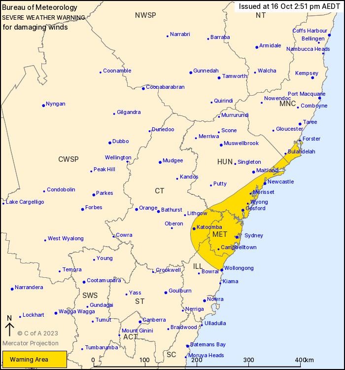
For people in Metropolitan and parts of Mid North Coast, Hunter,
Illawarra and Central Tablelands Forecast Districts.
Issued at 2:51 pm Monday, 16 October 2023.
Damaging winds for central NSW during this afternoon.
Weather Situation: A frontal system tracking north along the coast
today will result in damaging winds for central NSW. Winds will
ease as the system continues to track north and weakens during the
evening.
DAMAGING WINDS, averaging 60 to 70 km/h with peak gusts of around
100 km/h are expected about central NSW, extending from Wollongong
to Forster during this afternoon. Winds are forecast to ease below
warning thresholds this evening.
Locations which may be affected include Newcastle, Gosford,
Sydney, Parramatta, Wollongong and Katoomba.
98 km/h wind gust was recorded at Mount Boyce at 2:29 pm.
98 km/h wind gust was recorded at Camden at 2:42 pm.
94 km/h wind gust was recorded at Bellambi at 2:33 pm.
The State Emergency Service advises that people should:
* Move vehicles under cover or away from trees.
* Secure or put away loose items around your house, yard and
balcony.
* Keep at least 8 metres away from fallen power lines or objects
that may be energised, such as fences.
* Trees that have been damaged by fire are likely to be more
unstable and more likely to fall.
* Report fallen power lines to either Ausgrid (131 388), Endeavour
Energy (131 003), Essential Energy (132 080) or Evoenergy (131 093)
as shown on your power bill.
* Stay vigilant and monitor conditions. Note that the landscape
may have changed following bushfires.
* For emergency help in floods and storms, ring your local SES
Unit on 132 500.
16/Oct/2023 03:57 AM


