
Source: Bureau of Meteorology
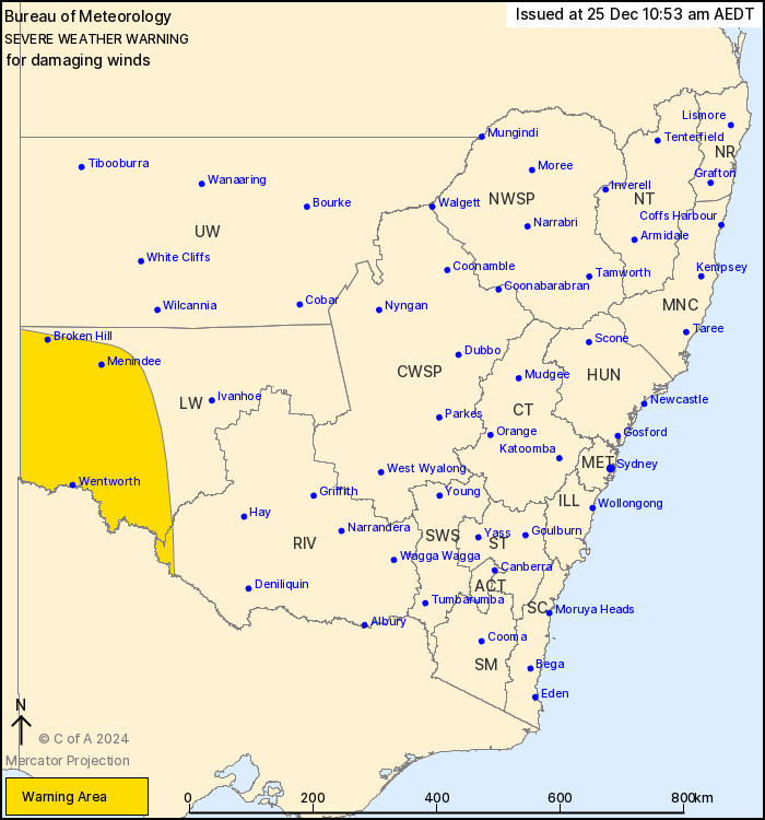
For people in parts of Lower Western and Riverina Forecast
Districts.
Issued at 10:53 am Wednesday, 25 December 2024.
Damaging wind gusts to develop over southwestern NSW on Thursday
afternoon.
Weather Situation: A cold front reaches the southwestern state
border in the late afternoon on Thursday before crossing the Lower
Western and reaching the Riverina around sunset. Northwesterly
winds will strengthen and shift to west to southwesterly on and
immediately behind the front before weakening by late Thursday
evening.
Isolated west to southwesterly DAMAGING WIND GUSTS with peak gusts
of around 100 km/h are possible from the late afternoon along and
immediately behind the cold front over the far western Riverina,
and Lower Western district to the west of Balranald.
Winds are expected to ease below warning thresholds everywhere by
late Thursday evening.
Locations which may be affected include Broken Hill, Wentworth,
Menindee and Balranald.
The State Emergency Service advises that people should:
* Move vehicles under cover or away from trees.
* Secure or put away loose items around your house, yard and
balcony.
* Keep at least 8 metres away from fallen power lines or objects
that may be energised, such as fences.
* Trees that have been damaged by fire are likely to be more
unstable and more likely to fall.
* Report fallen power lines to either Ausgrid (131 388), Endeavour
Energy (131 003), Essential Energy (132 080) or Evoenergy (131 093)
as shown on your power bill.
* Stay vigilant and monitor conditions. Note that the landscape
may have changed following bushfires.
* For emergency help in floods and storms, ring your local SES
Unit on 132 500.
25/Dec/2024 12:04 AM

