
Source: Bureau of Meteorology
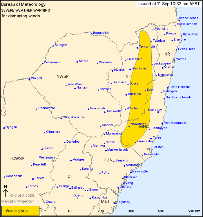
For people in parts of Mid North Coast, Northern Tablelands and
Hunter Forecast Districts.
Issued at 10:32 am Thursday, 11 September 2025.
Damaging wind gusts continuing about the northern ranges, easing
this afternoon.
Weather Situation: A low pressure system that brought heavy
rainfall and damaging winds to coastal parts of the state overnight
has now moved offshore, easing conditions slightly across coastal
parts. A vigorous westerly flow is expected to remain about
elevated parts of the northeast into this afternoon, until the low
moves further offshore.
DAMAGING WESTERLY WIND GUSTS with peak gusts of around 90 km/h are
expected to continue over elevated parts of the Hunter, Mid North
Coast and Northern Tablelands into the afternoon.
Locations which may be affected include Drake, Ebor, Nowendoc,
Gloucester, Barrington Tops and Yarrowitch.
The State Emergency Service advises that people should:
* Move vehicles under cover or away from trees.
* Secure or put away loose items around your house, yard and
balcony.
* Keep at least 8 metres away from fallen power lines or objects
that may be energised, such as fences.
* Trees that have been damaged by fire are likely to be more
unstable and more likely to fall.
* Report fallen power lines to either Ausgrid (131 388), Endeavour
Energy (131 003), Essential Energy (132 080) or Evoenergy (131 093)
as shown on your power bill.
* Stay vigilant and monitor conditions. Note that the landscape
may have changed following bushfires.
* For emergency help in floods and storms, ring your local SES
Unit on 132 500.
11/Sep/2025 12:37 AM


