
Source: Bureau of Meteorology
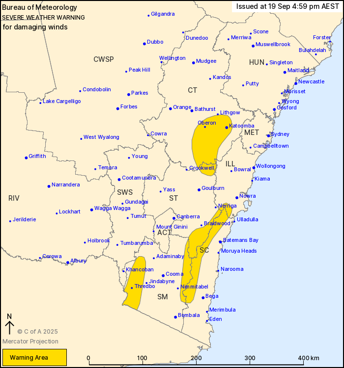
For people in parts of Illawarra, South Coast, Central Tablelands,
Southern Tablelands and Snowy Mountains Forecast Districts.
Issued at 4:59 pm Friday, 19 September 2025.
Damaging winds developing over parts of the southeast.
Weather Situation: A cold front is expected to cross the state
tonight with northwesterly winds strengthening ahead of the front.
The front will cross into the Tasman Sea during Saturday morning,
with strong westerly winds persisting in its wake.
For the SNOWY MOUNTAINS and SOUTHEAST COASTAL RANGES: DAMAGING
WINDS averaging 55 to 65 km/h with peak gusts around 100 km/h are
possible from this evening.
For ALPINE AREAS above 1900 metres: DAMAGING WINDS averaging 80 to
90 km/h with peak gusts around 110 km/h are possible from this
evening.
For the BLUE MOUNTAINS: DAMAGING WINDS averaging 55 to 65 km/h
with peak gusts around 90 km/h are possible on Saturday
morning.
Winds are expected to ease below warning thresholds by late
Saturday morning.
Locations which may be affected include Katoomba, Oberon, Thredbo,
Jenolan Caves, Taralga, Araluen, Perisher Valley and Charlotte
Pass.
The State Emergency Service advises that people should:
* Move vehicles under cover or away from trees.
* Secure or put away loose items around your house, yard and
balcony.
* Keep at least 8 metres away from fallen power lines or objects
that may be energised, such as fences.
* Trees that have been damaged by fire are likely to be more
unstable and more likely to fall.
* Report fallen power lines to either Ausgrid (131 388), Endeavour
Energy (131 003), Essential Energy (132 080) or Evoenergy (131 093)
as shown on your power bill.
* Stay vigilant and monitor conditions. Note that the landscape
may have changed following bushfires.
* For emergency help in floods and storms, ring your local SES
Unit on 132 500.
19/Sep/2025 07:05 AM


