
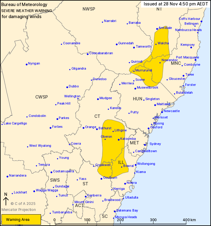
Source: Bureau of Meteorology
For people in parts of Mid North Coast, Hunter, Illawarra, Central
Tablelands, Southern Tablelands, Northern Tablelands and North West
Slopes and Plains Forecast Districts.
Issued at 4:50 pm Friday, 28 November 2025.
Damaging winds developing through elevated parts of the state
during Saturday morning.
Weather Situation: A cold front will sweep across southern parts
of NSW during Saturday, with west to northwesterly winds
strengthening ahead of the front. Winds will ease behind the front
by Saturday evening.
Strong west to northwesterly winds averaging 50 to 60 km/h with
DAMAGING WIND GUSTS of around 90 km/h are possible from mid-morning
Saturday.
Winds are expected to ease below warning thresholds by early
Saturday evening.
Locations which may be affected include Bowral, Katoomba,
Nowendoc, Murrurundi, Walcha and Lithgow.
The State Emergency Service advises that people should:
* Move vehicles under cover or away from trees.
* Secure or put away loose items around your house, yard and
balcony.
* Keep at least 8 metres away from fallen power lines or objects
that may be energised, such as fences.
* Trees that have been damaged by fire are likely to be more
unstable and more likely to fall.
* Report fallen power lines to either Ausgrid (131 388), Endeavour
Energy (131 003), Essential Energy (132 080) or Evoenergy (131 093)
as shown on your power bill.
* Stay vigilant and monitor conditions. Note that the landscape
may have changed following bushfires.
* For emergency help in floods and storms, ring your local SES
Unit on 132 500.
28/Nov/2025 06:11 AM

