
Source: Bureau of Meteorology
For people in parts of Upper Western Forecast District.
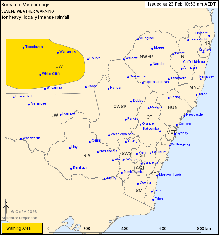
Issued at 10:53 am Monday, 23 February 2026.
Heavy rainfall persisting about the northwest, with locally
intense falls possible on Tuesday.
Weather Situation: An extremely humid airmass lies over central
Australia, focused around a slow-moving tropical low over the
southern Northern Territory. A trough extending into the northwest
of NSW is forecast to deepen on Tuesday, increasing the risk of
heavy falls.
HEAVY RAINFALL which may lead to FLASH FLOODING is forecast about
parts of the Upper Western district through today and into Tuesday.
Six-hourly rainfall totals between 30 and 60 mm are likely.
24-hourly rainfall totals between 50 and 90 mm are likely, with
isolated totals to 130 mm possible.
Locally INTENSE RAINFALL which may lead to DANGEROUS AND
LIFE-THREATENING FLASH FLOODING is also possible on Tuesday with
embedded thunderstorms, more likely near the SA border from early
morning. Isolated six-hourly rainfall totals of around 90 mm are
possible.
There remains uncertainty around the future movement and strength
of the low pressure system over central Australia that is driving
this weather. Periods of heavy rainfall may affect western New
South Wales until the middle of the week.
Flood Watches and Warnings are current for the area. Please refer
to https://www.bom.gov.au/weather-and-climate/warnings-and-alerts/
for more information.
Locations which may be affected include Tibooburra, White Cliffs,
Wanaaring, Louth, Tilpa and Fords Bridge.
The State Emergency Service advises that people should:
* Don't drive, ride or walk through flood water.
* Keep clear of creeks and storm drains.
* If you are trapped by flash flooding, seek refuge in the highest
available place and ring 000 if you need rescue.
For emergency help in flood and storms, ring the SES on 132
500.
Stay updated on the Hazards Near Me NSW app or the ACT ESA website
(https://esa.act.gov.au).
23/Feb/2026 12:27 AM

