
Source: Bureau of Meteorology
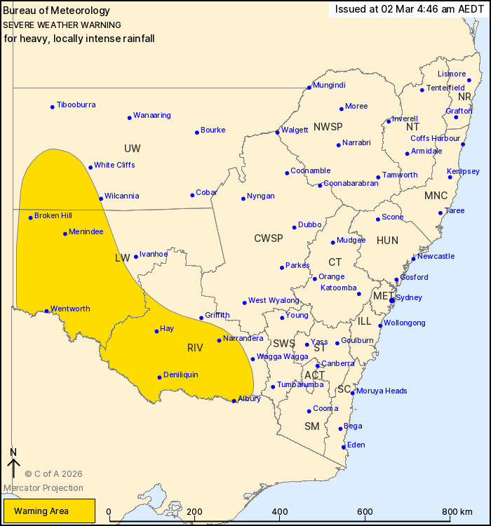
For people in Riverina, Lower Western and parts of Upper Western
Forecast Districts.
Issued at 4:46 am Monday, 2 March 2026.
HEAVY RAINFALL TODAY, LOCALLY INTENSE RAINFALL POSSIBLE THIS
MORNING
Weather Situation: Tropical humidity continues on the eastern
flank of a low in northwest Victoria, resulting in a broad rainband
with isolated thunderstorms. A trough is moving through the
southwest of state today with rainfall clearing from the west in
its wake.
HEAVY RAINFALL which may lead to FLASH FLOODING is possible for
southwestern parts of the Upper Western, Lower Western and Riverina
forecast districts today. Six-hourly rainfall totals between 40 to
70 mm are likely. Heavy rainfall is expected to ease in the Upper
Western and Lower Western forecast districts during the
afternoon.
Locally INTENSE RAINFALL which may lead to DANGEROUS AND
LIFE-THREATENING FLASH FLOODING is possible throughout the warning
area with thunderstorms. Six-hourly rainfall totals between 70 to
100 mm are possible. The risk of INTENSE RAINFALL decreases during
the morning.
Flood Watches and Warnings are current for the area. Please refer
to https://www.bom.gov.au/weather-and-climate/warnings-and-alerts/
for more information.
Locations which may be affected include Albury, Deniliquin, Broken
Hill, Hay, Wentworth and Narrandera.
65.2 MM WAS RECORDED AT FOWLERS GAP IN THE 2 HOURS TO 4:30
AM.
63.2 MM WAS RECORDED AT MOUNT WOOWOOLARAH IN THE 2 HOURS TO 3:27
AM.
The State Emergency Service advises that people should:
* Don't drive, ride or walk through flood water.
* Keep clear of creeks and storm drains.
* If you are trapped by flash flooding, seek refuge in the highest
available place and ring 000 if you need rescue.
For emergency help in flood and storms, ring the SES on 132
500.
Stay updated on the Hazards Near Me NSW app or the ACT ESA website
(https://esa.act.gov.au).
01/Mar/2026 08:02 PM

