
Source: Bureau of Meteorology
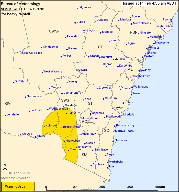
For people in parts of South West Slopes, Riverina and Snowy
Mountains Forecast Districts.
Issued at 4:55 am Friday, 14 February 2025.
Heavy falls possible over the southern ranges and slopes
today.
Weather Situation: A surface trough is approaching the southern
ranges this morning, drawing in a humid airmass from the north.
Areas of rain and embedded thunderstorms are forecast to increase
throughout Friday morning and early afternoon.
HEAVY RAINFALL which may lead to FLASH FLOODING is possible from
this morning in the warning area with thunderstorms. 6 hourly
rainfall totals between 20 to 40 mm are likely, with isolated falls
of up to 70 mm possible. 24 hourly rainfall totals of 30 to 60 mm
are also likely, with isolated falls up to 100 mm possible.
HEAVY RAINFALL is expected to ease in the warning area by Friday
evening.
Locations which may be affected include Tumbarumba, Cabramurra,
Selwyn, Tumut, Khancoban and Holbrook.
The State Emergency Service advises that people should:
* Don't drive, ride or walk through flood water.
* Keep clear of creeks and storm drains.
* If you are trapped by flash flooding, seek refuge in the highest
available place and ring 000 if you need rescue.
* Be aware that run-off from rainfall in fire affected areas may
behave differently and be more rapid. It may also contain debris
such as ash, soil, trees and rocks.
* After bushfires, heavy rain and the loss of foliage can make the
ground soft and heavy, leading to a greater chance of
landslides.
* Stay vigilant and monitor conditions. Note that the landscape
may have changed following bushfires.
* For emergency help in floods and storms, ring your local SES
Unit on 132 500.
13/Feb/2025 07:49 PM

