
Source: Bureau of Meteorology
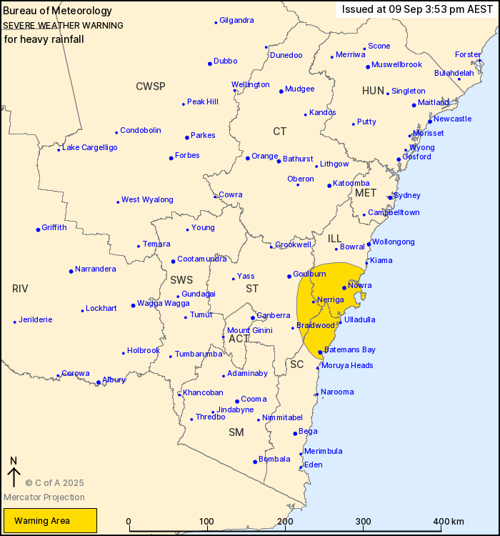
For people in parts of Illawarra, South Coast and Southern
Tablelands Forecast Districts.
Issued at 3:53 pm Tuesday, 9 September 2025.
Heavy rainfall forecast to develop from Wednesday afternoon.
Weather Situation: a complex low is forecast to move over
southeastern NSW and then push offshore around Jervis Bay later on
Wednesday, with heavy showers and rain developing in a
southeasterly flow, particularly about the ranges and elevated
parts of the warning area.
HEAVY RAINFALL which may lead to FLASH FLOODING is forecast from
Wednesday evening for parts of the southern Illawarra as well as
the northern South Coast and eastern Southern Tablelands,
particularly about elevated parts. Six-hourly rainfall totals
between 60 to 100 mm are possible with 24-hour totals up to 140
mm.
Rainfall is expected to contract to the coast during late
Wednesday and ease by Thursday morning.
Locations which may be affected include Nowra, Batemans Bay,
Ulladulla and Nerriga.
The State Emergency Service advises that people should:
* Don't drive, ride or walk through flood water.
* Keep clear of creeks and storm drains.
* If you are trapped by flash flooding, seek refuge in the highest
available place and ring 000 if you need rescue.
* Be aware that run-off from rainfall in fire affected areas may
behave differently and be more rapid. It may also contain debris
such as ash, soil, trees and rocks.
* After bushfires, heavy rain and the loss of foliage can make the
ground soft and heavy, leading to a greater chance of
landslides.
* Stay vigilant and monitor conditions. Note that the landscape
may have changed
09/Sep/2025 06:00 AM


