
Source: Bureau of Meteorology
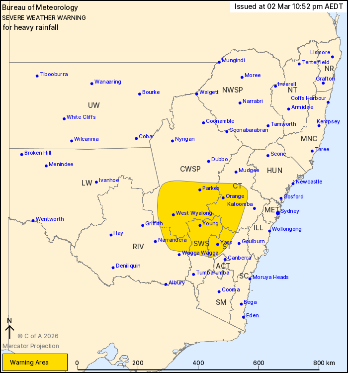
For people in parts of Central Tablelands, Southern Tablelands,
Central West Slopes and Plains, South West Slopes and Riverina
Forecast Districts.
Issued at 10:52 pm Monday, 2 March 2026.
Heavy rainfall continuing over parts of southeast New South Wales
overnight, easing Tuesday morning.
Weather Situation: Tropical humidity continues on the eastern
flank of a low situated over the Riverina, resulting in a broad
rainband. The low is moving slowly eastward and is forecast to be
over the eastern Riverina by Tuesday morning, with rainfall
clearing from the west in its wake.
HEAVY RAINFALL which may lead to FLASH FLOODING is possible for
parts of the Riverina, Central West Slopes and Plains, Central
Tablelands, South West Slopes and Southern Tablelands. Six-hourly
rainfall totals between 40 to 70 mm are possible.
The risk of HEAVY RAINFALL is forecast to ease Tuesday
morning.
Flood Watches and Warnings are current for the area. Please refer
to https://www.bom.gov.au/weather-and-climate/warnings-and-alerts/
for more information.
Locations which may be affected include Orange, Yass, Parkes,
Young, West Wyalong and Bathurst.
Severe weather is no longer occurring in the Lower Western, Upper
Western, Snowy Mountains and Australian Capital Territory districts
and the warning for these districts is CANCELLED.
The State Emergency Service advises that people should:
* Don't drive, ride or walk through flood water.
* Keep clear of creeks and storm drains.
* If you are trapped by flash flooding, seek refuge in the highest
available place and ring 000 if you need rescue.
For emergency help in flood and storms, ring the SES on 132
500.
Stay updated on the Hazards Near Me NSW app or the ACT ESA website
(https://esa.act.gov.au).
02/Mar/2026 12:00 PM

