
Source: Bureau of Meteorology
Issued at 4:29 pm ACST [4:59 pm AEST] on Saturday 16 March
2024
Headline:
Tropical Cyclone Megan has formed in the Gulf of
Carpentaria.
Areas Affected:
Warning Zone
Alyangula (Groote Eylandt) in NT to Mornington Island in Qld,
including Borroloola but not including Ngukurr or Mornington
Island.
Watch Zone
Mornington Island in Qld as well as adjacent parts of the
Carpentaria District inland to Robinson River in NT.
Cancelled Zone
None.
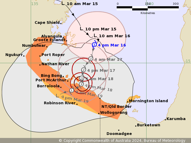
Details of Tropical Cyclone Megan at 3:30 pm ACST [4:00 pm
AEST]:
Intensity: Category 1, sustained winds near the centre of 85
kilometres per hour with wind gusts to 120 kilometres per
hour.
Location: within 30 kilometres of 14.2 degrees South 137.8 degrees
East, estimated to be 150 kilometres east southeast of Alyangula
and 260 kilometres northeast of Borroloola.
Movement: slow moving.
Tropical Cyclone Megan has formed to the east of Groote Eylandt
and is forecast to continue to intensify as it moves south slowly
over the weekend towards the southern Gulf of Carpentaria coast.
Megan is forecast to reach category 2 tonight and further intensify
to Category 3 Sunday night before landfall on Monday.
Once over land, Megan should weaken quickly as it tracks west
through the Northern Territory.
Hazards:
Gales with DAMAGING WIND GUSTS of 110 km/h are possible over
Groote Eylandt through today, and may continue into Sunday.
Gales with DAMAGING WIND GUSTS of 100 km/h may develop between
Numbulwar in the Northern Territory and Mornington Island in
Queensland, including Borroloola, overnight tonight or on Sunday.
Gales may extend inland to Robinson River overnight Sunday into
Monday if the system moves more quickly to the south.
Gales with DAMAGING WIND GUSTS of 100 km/h are possible on
Mornington Island itself from early Monday, if the system tracks
further east than forecast.
DESTRUCTIVE wind gusts in excess of 125 km/h are possible about
the southwestern Gulf of Carpentaria coast, near the system centre,
from late Sunday.
The VERY DESTRUCTIVE CORE of Tropical Cyclone Megan with wind
gusts up to 185 km/h is expected to cross the coast between Nathan
River in the Northern Territory and the Queensland/Northern
Territory border from early Monday.
INTENSE RAINFALL is possible about Groote Eylandt and coastal
parts of the Carpentaria District during the weekend.
HEAVY RAINFALL is occurring over eastern parts of the Top End and
will continue over the weekend, with the heaviest falls in coastal
and island locations during today before reaching further inland
into the Carpentaria forecast districts on Sunday. A separate
severe weather warning is current for heavy rainfall for parts of
the Arnhem district for monsoon weather conditions.
A STORM TIDE with ABNORMALLY HIGH TIDES is likely along the
southern Gulf of Carpentaria coast this weekend and into Monday.
Large waves may produce MINOR FLOODING along the foreshore.
Recommended Action:
The Northern Territory Emergency Service advise:
For the communities in the area of the Cyclone Warning:
- Enact your household plan
- Prepare your property now
- Stay informed
- Take extra care on the roads
For the communities in the area of the Cyclone Watch:
- Prepare now
- Stay informed
- Monitor conditions
QFES advises:
People between the Queensland/ Northern Territory border and
Mornington Island, not including Mornington Island, should take
precautions and listen to the next advice.
People between on Mornington Island should consider what action
they will need to take if the cyclone threat increases.
- Information is available from your local government
- For cyclone preparedness and safety advice, visit Queensland's
Disaster Management Services website
(www.disaster.qld.gov.au)
- For emergency assistance call the Queensland State Emergency
Service (SES) on 132 500 (for assistance with storm damage, rising
flood water, fallen trees on buildings or roof damage).
Current
Tropical Cyclones
16/Mar/2024 07:18 AM


