
Source: Bureau of Meteorology
Issued at 7:11 am ACST on Saturday 21 March 2026
Headline:
Tropical Cyclone Narelle is moving westwards through the Gulf of
Carpentaria and will impact the eastern Top End late
Saturday.
Areas Affected:
Warning Zone
Nhulunbuy to Port McArthur, including Borroloola, Numbulwar,
Alyangula, and Gapuwiyak.
Watch Zone
Extending west to include Ramingining, Bulman, and Ngukurr.
Cancelled Zone
None.
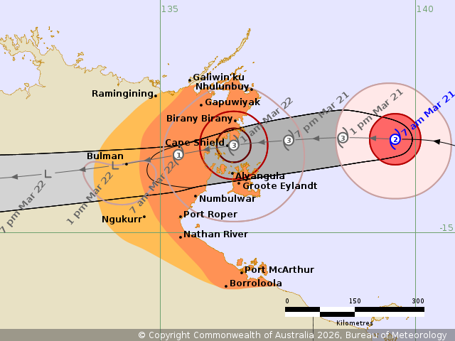
Details of Tropical Cyclone Narelle 34U at 6:30 am ACST:
Intensity: Category 2, sustained winds near the centre of 110
kilometres per hour with wind gusts to 155 kilometres per
hour.
Location: within 35 kilometres of 13.2 degrees South 139.6 degrees
East, estimated to be 255 kilometres west southwest of Weipa and
355 kilometres east northeast of Alyangula.
Movement: west at 20 kilometres per hour.
Tropical Cyclone Narelle is over the warm waters of the Gulf of
Carpentaria. Narelle is forecast to strengthen during Saturday as
it tracks quickly westwards towards the eastern Top End.
Narelle is forecast to cross the eastern Top End coast overnight
Saturday or early Sunday morning, most likely between Birany Birany
and Numbulwar, as a severe tropical cyclone. Narelle will then
weaken as it moves inland across the Top End on Sunday and
Monday.
Hazards:
VERY DESTRUCTIVE WINDS with gusts to 185 km/h are forecast to
develop in coastal areas between about Birany Birany and Numbulwar,
including Groote Eylandt, Saturday evening and overnight into
Sunday as Narelle approaches from the east.
DESTRUCTIVE WIND GUSTS to 160 km/h are forecast to develop between
Birany Birany and Numbulwar, including Groote Eylandt from later
Saturday afternoon and possibly extending to be between Nhulunbuy
to Nathan River overnight Saturday or Sunday morning depending on
the movement of Narelle.
GALES with DAMAGING WIND GUSTS to 120 km/h are forecast to develop
in coastal and adjacent inland areas between Gapuwiyak and Port
McArthur, including Nhulunbuy and Borroloola, from Saturday
afternoon and overnight into Sunday. These GALES may extend west to
Ramingining, Bulman, and Ngukurr on Sunday.
HEAVY RAINFALL which may lead to FLASH FLOODING is likely to
develop for coastal and adjacent inland areas over the eastern Top
End between Port McArthur and Nhulunbuy from Saturday afternoon,
then extending further inland during Sunday. LOCALLY INTENSE
RAINFALL leading to DANGEROUS AND LIFE-THREATENING FLASH FLOODING
is likely over the eastern Top End between Numbulwar and Birany
Birany, including Groote Eylandt, during Saturday afternoon and
evening
Tides will be higher than normal between Nhulunbuy and Port
McArthur later Saturday and Sunday. LARGE WAVES may produce MINOR
FLOODING of low-lying coastal areas. A potentially DANGEROUS STORM
TIDE between Cape Shield and Port Roper is possible as the cyclone
centre crosses the coast with DAMAGING WAVES and DANGEROUS
FLOODING.
Recommended Action:
NTES advises:
People between Nhulunbuy and Port McArthur, including Borroloola,
Numbulwar, Alyangula, and Gapuwiyak, should immediately commence or
continue preparations, especially securing boats and
property.
People further west including Ramingining, Bulman, and Ngukurr,
should consider what action they will need to take if the cyclone
threat increases.
- For cyclone preparedness and safety advice, visit the Secure NT
website at http://www.securent.nt.gov.au
- For emergency assistance call the Northern Territory Emergency
Service (NTES) on 132 500 (for assistance with storm damage, rising
flood water, fallen trees on buildings or roof damage).
Current
Tropical Cyclones
20/Mar/2026 09:45 PM

