
Source: Bureau of Meteorology
Issued at 10:33 am ACST on Friday 21 November 2025
Headline:
Tropical Cyclone Fina is impacting the Cobourg Peninsula,
extending to other parts of the northwest Top End today and on
Saturday.
Areas Affected:
Warning zone: The Tiwi Islands, Dundee Beach to Warruwi, and
inland to Batchelor. This includes Darwin, Cobourg Peninsula,
Minjilang and Gunbalanya, and also Pirlangimpi, Milikapiti and
Wurrumiyanga.
Watch zone: Wadeye to Daly River Mouth.
Cancelled zone: None.
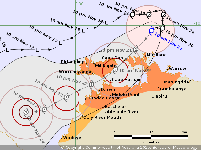
Details of Tropical Cyclone Fina 02U at 9:30 am ACST:
Intensity: Category 1, sustained winds near the centre of 85
kilometres per hour with wind gusts to 120 kilometres per
hour.
Location: within 35 kilometres of 10.2 degrees South 132.8 degrees
East, estimated to be 110 kilometres north northeast of Minjilang
and 325 kilometres northeast of Darwin.
Movement: slow moving.
Tropical Cyclone Fina, currently a category 1 cyclone, is moving
slowly southwest and is expected to strengthen to a category 2
system whilst tracking southwest during today.
Fina is forecast to approach the Cobourg Peninsula and Tiwi
Islands tonight before continuing southwest through the Van Diemen
Gulf on Saturday.
Fina is forecast to further intensify to a severe tropical cyclone
during Sunday afternoon in the southern Timor Sea. There continues
to remain a chance that it could reach category 3 intensity
earlier, during late Friday or early Saturday as it moves into the
Van Diemen Gulf.
Hazards:
GALES with DAMAGING WIND GUSTS to 120 km/h are occurring over the
Cobourg Peninsula between Cape Don and Warruwi. Gales are expected
to extend further west to include the Tiwi Islands during late
Friday, and to Darwin during Saturday. Gales could extend inland to
Gunbalanya and Batchelor during Saturday if Fina moves further
south. Gales may extend further southwest to Daly River Mouth and
Wadeye later on Saturday or overnight into early Sunday
morning.
DESTRUCTIVE WIND GUSTS to 155km/h may develop between Cape Don and
Minjilang on Friday as the system nears the coast, extending to the
Tiwi Islands early Saturday and possibly to Darwin later on
Saturday. Destructive winds may extend east to Warruwi later Friday
if the system takes a track further east.
HEAVY RAINFALL which may lead to FLASH FLOODING is possible along
coastal areas between the Tiwi Islands and Warruwi from Friday,
extending to the coast and nearby inland across the western Top End
including Darwin on Saturday. HEAVY to LOCALLY INTENSE RAINFALL may
occur near and south of the cyclone centre during Saturday.
Coastal residents on the Tiwi Islands, and between Cape Hotham and
Warruwi are specifically warned of a DANGEROUS STORM TIDE as the
cyclone centre crosses the coast during Friday and Saturday. Tides
are likely to rise significantly above the normal high tide, with
DAMAGING WAVES and DANGEROUS FLOODING.
Recommended Action:
NTES advises people between Cape Don to Minjilang should complete
preparations quickly and be prepared to shelter in a safe place.
NTES advises people on the Tiwi Islands, and between Dundee Beach
to Warruwi, including the Cobourg Peninsula, Darwin and Batchelor,
should immediately commence or continue preparations, especially
securing boats and property, using available daylight hours. NTES
advises people elsewhere near and between Wadeye and Dundee Beach,
should consider what action they will need to take if the cyclone
threat increases. For cyclone preparedness and safety advice, visit
the Secure NT website (www.securent.nt.gov.au). For emergency
assistance call the Northern Territory Emergency Service (NTES) on
132 500 (for assistance with storm damage, rising flood water,
fallen trees on buildings or roof damage).
Current
Tropical Cyclones
21/Nov/2025 01:17 AM

