
Source: Bureau of Meteorology
Issued at 1:35 pm AEST on Tuesday 17 February 2026
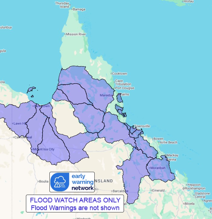
Flood Watch Number: 9
FLOODING LIKELY TO BECOME MORE WIDESPREAD OVER THE NEXT FEW
DAYS
A broad trough system will linger over northern Queensland for
several days, maintaining deep tropical moisture and enhancing
shower and storm activity. Moderate to locally heavy falls are
possible, with the highest totals likely close to the coast and
ranges.
Catchments are relatively wet to very wet after recent rainfall,
with river level rises and areas of flooding likely to become more
widespread over the next few days. The Flood Watch has been
expanded to include additional catchments across the Gulf Country
and parts of the Cape York Peninsula, as well as the lower Burdekin
and Connors-Isaac catchments.
Rapid river level rises and flash flooding are possible in areas
that receive the heaviest rainfall. Road closures and community
isolation are occurring in some areas, with additional areas likely
to be affected over the next few days.
The situation will be monitored closely and Flood Warnings will be
issued as required.
Catchments likely to be affected include:
Mulgrave and Russell Rivers
Tully River
Murray River
Black River
Ross and Bohle Rivers
Haughton River
Belyando and Suttor Rivers to Burdekin Falls Dam
Burdekin River to Burdekin Falls Dam
Burdekin River downstream of Burdekin Falls Dam
Connors, Isaac and Styx Rivers and Plane Creek
Nicholson River
Leichhardt River
Lower Flinders River
Cloncurry River
Gilbert River
Staaten River
Mitchell River
(Including Magnificent Creek at Kowanyama)
Flood warnings are current for numerous catchments across the
state, including the Cape River to Burdekin Falls Dam, which has
been removed from this Flood Watch.
For the latest flood and weather warnings see
www.bom.gov.au/weather-and-climate/warnings-and-alerts
For the latest rainfall and river level information see
www.bom.gov.au/australia/flood
Safety Advice:
Don't drive, walk, swim or play in floodwater because it is
dangerous.
Stay away from flooded drains, rivers, streams and
waterways.
Obey road closure signs. Plan ahead so you don't drive on flooded
roads.
Check the ABC and local media for updates. The situation can
change quickly, so stay informed.
For local emergency management warnings and advice visit
www.disaster.qld.gov.au/warnings.
For emergency assistance call SES on telephone number 132 500. In
life-threatening emergencies, call 000 (triple zero)
immediately.
Rainfall and River
Conditions Map
17/Feb/2026 03:53 AM

