
Source: Bureau of Meteorology
Flood Watch Number: 22
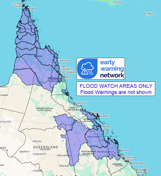
MINOR TO MAJOR FLOODING POSSIBLE ACROSS COASTAL RIVERS BETWEEN
COOKTOWN TO ROCKHAMPTON AND THE CAPE YORK PENINSULA
A tropical low is developing in the Coral Sea, and is likely to
cross the coast between Cairns and Ayr late Saturday or early
Sunday. The low is now forecast to reach tropical cyclone intensity
prior to reaching the coast. However, rainfall impacts are likely
to be similar whether or not it becomes a tropical cyclone. Heavy
rainfall will intensify near this low pressure system over the next
few days. The areas of heaviest rainfall will depend on the
location of the low pressure system, and will be primarily south of
the centre.
Further north, a monsoon trough extends across the northern Cape
York Peninsula, and is likely to bring flooding to both Eastern and
Western Cape catchments.
Many catchments are wet to saturated following recent heavy
rainfall and rapid and dangerous river level rises are likely,
particularly for the Northern Tropical Coast, and adjacent inland
catchments.
Elevated river levels and areas of flooding are already occurring
in some catchments across northern Queensland, with further minor
to major flooding likely to develop with rainfall from Friday and
into the weekend.
Catchments south of Ayr are drier and may take longer to respond
to rainfall, with possible minor to moderate flooding developing
from Saturday.
A Severe Weather Warning for heavy, locally intense rainfall is
current for parts of the Flood Watch area. A Tropical Cyclone
Advice is current for parts of the Flood Watch area.
Catchments likely to be affected include:
Jacky Jacky Creek
Olive and Pascoe Rivers
Lockhart River
Stewart River
Normanby River
Jeannie River
Endeavour River
Daintree River(Including Bloomfield River)
Mossman River
Barron River
Murray River
Belyando and Suttor Rivers to Burdekin Falls Dam
Cape River to Burdekin Falls Dam
Don and Proserpine Rivers
Pioneer River
Connors, Isaac and Styx Rivers and Plane Creek
Mackenzie and Fitzroy Rivers and Shoalwater and Water Park
Creeks
Staaten River
Mitchell River
Coleman and Edward Rivers
Holroyd and Kendall Rivers
Archer and Coen Rivers
Watson River
Embley and Mission Rivers
Wenlock River
Ducie, Jackson and Skardon Rivers
Jardine River
Flood Warnings are current for the following catchment(s):
Daintree, Mulgrave and Russell, Johnstone, Tully, Herbert, Black,
Ross and Bohle, Haughton, Burdekin to Burdekin Falls Dam, Burdekin
downstream of Burdekin Falls Dam, Nicholson, Leichhardt, Upper
Flinders, Lower Flinders, Norman, Gilbert, Georgina and Eyre,
Diamantina and Thomson
For the latest flood and weather warnings see
www.bom.gov.au/weather-and-climate/warnings-and-alerts
For the latest rainfall and river level information see
www.bom.gov.au/australia/flood
Safety Advice:
- Don't drive, walk, swim or play in floodwater because it is
dangerous.
- Stay away from flooded drains, rivers, streams and
waterways.
- Obey road closure signs. Plan ahead so you don't drive on
flooded roads.
- Check the ABC and local media for updates. The situation can
change quickly, so stay informed.
For local emergency management warnings and advice visit
www.disaster.qld.gov.au/warnings.
For emergency assistance call SES on telephone number 132 500. In
life-threatening emergencies, call 000 (triple zero)
immediately.
Rainfall and River
Conditions Map
09/Jan/2026 03:18 AM


