
Source: Bureau of Meteorology
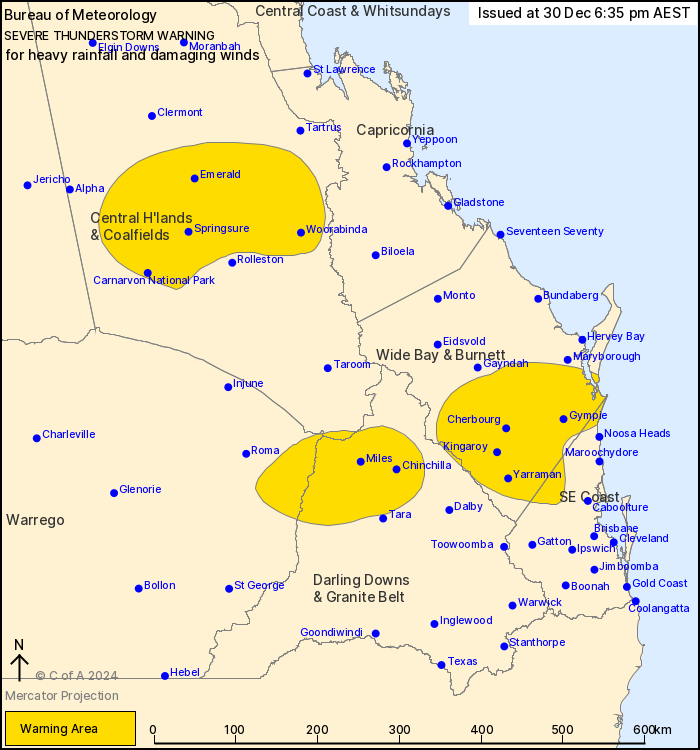
For people in parts of Central Highlands and Coalfields, Wide Bay
and Burnett, Maranoa and Warrego, Darling Downs and Granite Belt
and Southeast Coast Forecast Districts.
Issued at 6:35 pm Monday, 30 December 2024.
Severe thunderstorms continue across the southeast quarter of Qld
this evening.
Weather Situation: A moist and unstable airmass combined with an
upper trough is producing severe thunderstorms.
Severe thunderstorms are likely to produce heavy rainfall that may
lead to flash flooding and damaging winds over the next several
hours in parts of the Central Highlands and Coalfields, Maranoa and
Warrego and Darling Downs and Granite Belt districts. Locations
which may be affected include Emerald, Blackwater, Springsure,
Woorabinda, Mantuan Downs and Carnarvon National Park.
Severe thunderstorms are likely to produce heavy rainfall that may
lead to flash flooding over the next several hours in parts of the
Wide Bay and Burnett, Southeast Coast and Darling Downs and Granite
Belt districts. Locations which may be affected include Gympie,
Kingaroy, Cherbourg, Kilcoy, Nanango and Rainbow Beach.
82 MM WAS RECORDED AT KINGAROY IN THE 1 HOUR TO 4:36 PM
65 mm was recorded at Moffatt in the 2 hours to 4:30 pm
68 mm was recorded at Dalby in the 2 hours to 3:51 pm
43 mm was recorded at Jandowae-Macalister Road in the 30 minutes
to 3:28 pm
62.6 mm was recorded at Saddler Springs in the 1 hour to 1:12
pm
Emergency services advise people to:
* Park your car undercover away from trees.
* Close doors and windows.
* Keep asthma medications close by. Storms and wind can trigger
asthma attacks.
* Charge mobile phones and power banks in case the power goes
out.
* Put your pets somewhere safe and make sure they can be
identified in case they get lost.
* Do not drive now unless you have to because conditions are
dangerous.
* Tell friends, family and neighbours in the area.
* Go inside a strong building now. Stay inside until the storm has
passed.
30/Dec/2024 08:43 AM

