
Source: Bureau of Meteorology
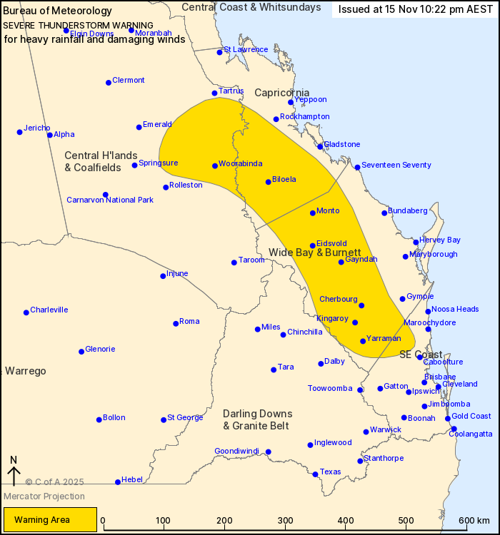
For people in parts of Central Highlands and Coalfields,
Capricornia, Wide Bay and Burnett, Southeast Coast and Darling
Downs and Granite Belt Forecast Districts.
Issued at 10:22 pm Saturday, 15 November 2025.
Severe thunderstorms persist about the southeast.
Weather Situation: Severe thunderstorms continuing in a moist
unstable airmass tonight.
Severe thunderstorms are likely to produce heavy rainfall that may
lead to flash flooding and damaging winds in the warning area over
the next several hours. Locations which may be affected include
Kingaroy, Biloela, Cherbourg, Monto, Woorabinda and Yarraman.
Observations in the last 4 hours to warning issue time:
84 MM WAS RECORDED AT CRACOW IN THE 45 MINUTES TO 9:31 PM.
65 MM WAS RECORDED AT KENILWORTH IN THE 30 MINUTES TO 5:50
PM.
67 MM WAS RECORDED AT COOLABINE CREEK IN THE 1 HOUR TO 5:54
PM.
48 mm was recorded at Mount Wolvi in the 30 minutes to 8:45
pm.
87 mm was recorded at Round Mountain in the 3 hours to 6:56
pm.
80 mm was recorded at Kooralbyn in the 3 hours to 6:56 pm.
80 mm was recorded at Maroochydore in the 1 hour to 6:15 pm.
80 mm was recorded at Buderim in the 1 hour to 6:10 pm.
87 mm was recorded at Mountain Creek in the 1 hour to
6:04pm.
Emergency services advise people to:
* Park your car undercover away from trees.
* Close doors and windows.
* Keep asthma medications close by. Storms and wind can trigger
asthma attacks.
* Charge mobile phones and power banks in case the power goes
out.
* Put your pets somewhere safe and make sure they can be
identified in case they get lost.
* Do not drive now unless you have to because conditions are
dangerous.
* Tell friends, family and neighbours in the area.
* Go inside a strong building now. Stay inside until the storm has
passed.
15/Nov/2025 12:29 PM

