
Source: Bureau of Meteorology
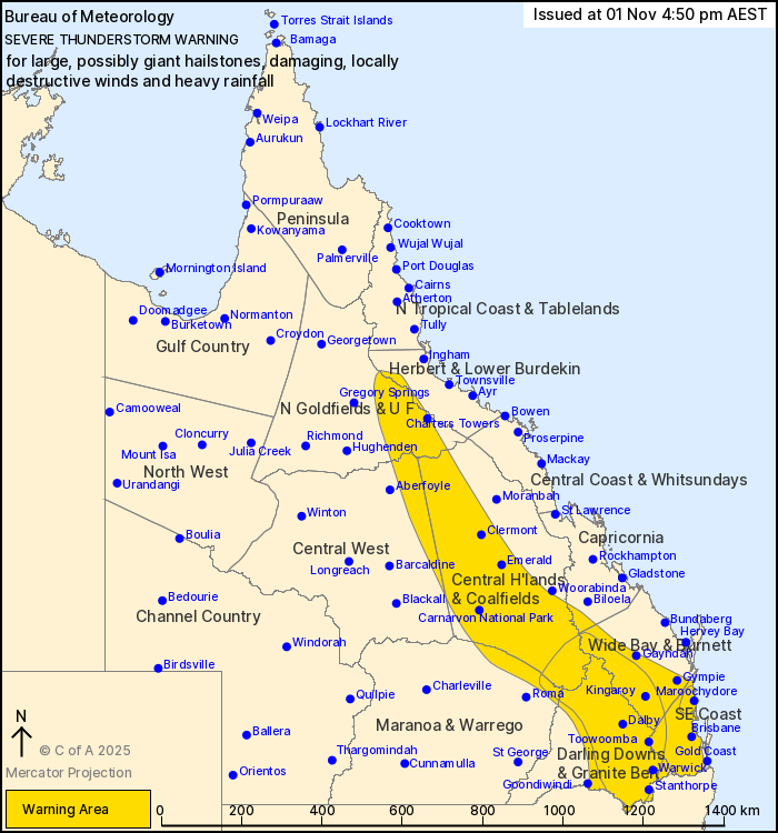
For people in Central Highlands and Coalfields, Darling Downs and
Granite Belt, Southeast Coast and parts of Northern Goldfields and
Upper Flinders, Herbert and Lower Burdekin, Central West,
Capricornia, Wide Bay and Burnett and Maranoa and Warrego Forecast
Districts.
Issued at 4:50 pm Saturday, 1 November 2025.
SEVERE THUNDERSTORMS WITH POSSIBLE GIANT HAIL AND DESTRUCTIVE
WINDS CONTINUING THROUGH SOUTHEAST PARTS OF THE STATE THIS
AFTERNOON AND ARE EXPECTED TO CONTINUE INTO THE EVENING.
Weather Situation: Strong heating of a moist airmass over
southeastern and central Queensland east of a surface trough is
creating unstable atmospheric conditions. This will combine with
strong winds in the upper atmosphere to provide a favourable
environment for the development of isolated to scattered severe
thunderstorms this afternoon and evening.
Severe thunderstorms are likely to produce large hailstones,
damaging winds and heavy rainfall that may lead to flash flooding
over the next several hours in the Central Highlands and
Coalfields, Darling Downs and Granite Belt, Southeast Coast and
parts of the Northern Goldfields and Upper Flinders, Herbert and
Lower Burdekin, Central West, Capricornia, Wide Bay and Burnett and
Maranoa and Warrego districts. Locations which may be affected
include Warwick, Toowoomba, Brisbane, Dalby, Maroochydore, Gympie,
Emerald, Clermont, Charters Towers, Kingaroy, Stanthorpe and
Ipswich.
VERY DANGEROUS THUNDERSTORMS are likely to produce large, possibly
giant hailstones, damaging, locally destructive winds and heavy
rainfall that may lead to flash flooding over the next several
hours in parts of the Central Highlands and Coalfields, Wide Bay
and Burnett, Darling Downs and Granite Belt, Southeast Coast and
Maranoa and Warrego districts. Locations which may be affected
include Warwick, Toowoomba, Dalby, Maroochydore, Kingaroy and
Stanthorpe.
5 CM HAIL STONES WERE REPORTED AT YULEBA AT 3:16 PM.
5 CM HAIL STONES WERE REPORTED AT HELIDON AT 2:35 PM.
5 CM HAIL STONES WERE REPORTED AT NOBBY AT 1:55 PM.
5 CM HAIL STONES WERE REPORTED AT CLIFTON AT 1:30 PM.
9 CM HAIL STONES WERE REPORTED AT PRATTEN AT 1:03 PM.
104 km/h wind gust was recorded at Dalby Airport at 4:14 pm.
46 mm of rainfall was recorded at O Connor (Weir River) in the 30
minutes to 4:00 pm.
2 cm hail stones were reported at Mt Walker at 12:44 pm.
Emergency services advise people to:
* If you have children make sure they are with you or an adult you
trust.
* Pack away, secure or tie down outdoor furniture, toys and
trampolines if it s safe to do so.
* Stay away from windows if there is giant hail.
* Park your car undercover away from trees.
* Close doors and windows.
* Keep asthma medications close by. Storms and wind can trigger
asthma attacks.
* Charge mobile phones and power banks in case the power goes
out.
* Put your pets somewhere safe and make sure they can be
identified in case they get lost.
* Do not drive now unless you have to because conditions are
dangerous.
* Tell friends, family and neighbours in the area.
* Go inside a strong building now. Stay inside until the storm has
passed.
01/Nov/2025 06:58 AM


