
Source: Bureau of Meteorology
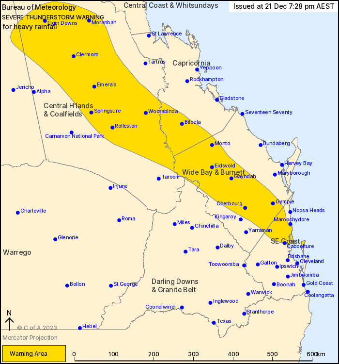
For people in parts of Central Highlands and Coalfields,
Capricornia, Wide Bay and Burnett, Southeast Coast, Central West
and Darling Downs and Granite Belt Forecast Districts.
Issued at 7:28 pm Thursday, 21 December 2023.
Severe thunderstorms continue in the southeast.
Weather Situation: Slow moving severe thunderstorms are ongoing in
a very humid airmass through southeast Queensland this evening and
are expected to persist tonight. Intense rainfall has eased for
now, but localised intense falls may redevelop tonight through the
Wide Bay and Burnett, Capricornia and Central Highlands and
Coalfields.
Severe thunderstorms are likely to produce heavy rainfall that may
lead to flash flooding in the warning area over the next several
hours. Locations which may be affected include Gympie, Emerald,
Clermont, Caboolture, Cooroy and Nambour.
Severe thunderstorms are no longer occurring in the Northern
Goldfields and Upper Flinders district and the warning for this
district is CANCELLED.
48.0 mm was recorded in 30 minutes to 5:18 pm at Moggill
Alert
54.0 mm was recorded in 1 hour to 17:16 at Dykehead (southwest of
Mundubbera)
76.0 mm was recorded in 1 hour to 3:07pm at Gormans Gap (south of
Toowoomba)
54.0 mm was recorded in 1 hour to 3:01 pm at Millbrook.
Emergency services advise people to:
* Park your car undercover away from trees.
* Close doors and windows.
* Keep asthma medications close by. Storms and wind can trigger
asthma attacks.
* Charge mobile phones and power banks in case the power goes
out.
* Put your pets somewhere safe and make sure they can be
identified in case they get lost.
* Do not drive now unless you have to because conditions are
dangerous.
* Tell friends, family and neighbours in the area.
* Go inside a strong building now. Stay inside until the storm has
passed.
21/Dec/2023 09:35 AM


