
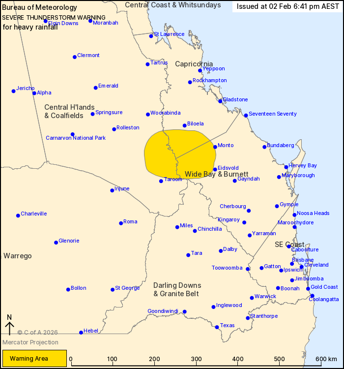
Source: Bureau of Meteorology
For people in parts of Central Highlands and Coalfields,
Capricornia and Wide Bay and Burnett Forecast Districts.
Issued at 6:41 pm Monday, 2 February 2026.
Severe thunderstorms continuing into the evening.
Weather Situation: A strong southeasterly surge continues to
trigger storms this evening. Some storms may stall when merging
bringing a heightened risk of heavy rainfall.
Severe thunderstorms are likely to produce heavy rainfall that may
lead to flash flooding in the warning area over the next several
hours. Locations which may be affected include Theodore and
Moura.
A separate Severe Weather Warning is current for damaging winds
about the Bunya Mountains, Main Range, and offshore islands in the
southeast. Refer
https://www.bom.gov.au/weather-and-climate/warnings-and-alerts
Severe thunderstorms are no longer occurring in the Darling Downs
and Granite Belt district and the warning for this district is
CANCELLED.
39 mm of rainfall was recorded at Mt Playfair (Carnarvon NP) in
the 30 minutes to 4:24 pm.
43 mm of rainfall was recorded on the O'Connor (west of
Millmerran) in the 30 minutes 3.05 pm.
Emergency services advise people to:
* Park your car undercover away from trees.
* Close doors and windows.
* Keep asthma medications close by. Storms and wind can trigger
asthma attacks.
* Charge mobile phones and power banks in case the power goes
out.
* Put your pets somewhere safe and make sure they can be
identified in case they get lost.
* Do not drive now unless you have to because conditions are
dangerous.
* Tell friends, family and neighbours in the area.
* Go inside a strong building now. Stay inside until the storm has
passed.
02/Feb/2026 08:47 AM


