
Source: Bureau of Meteorology
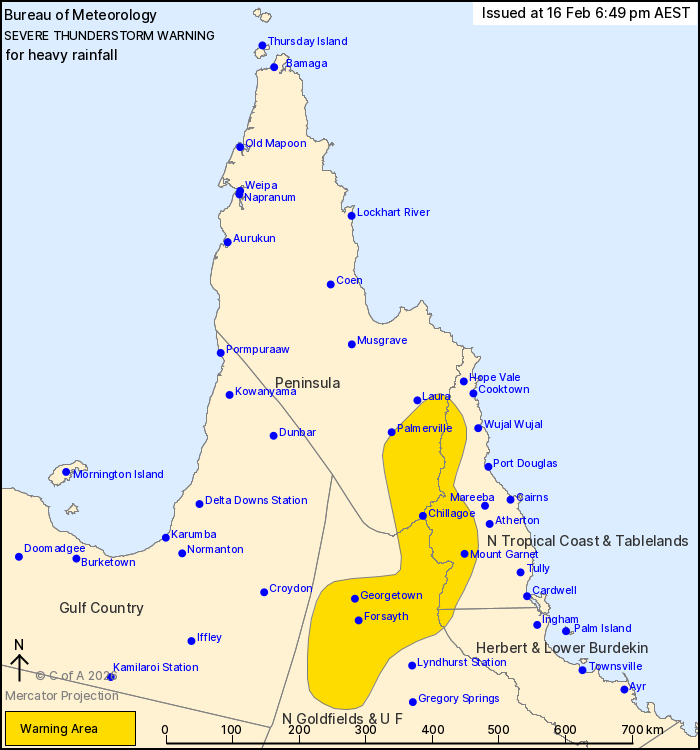
For people in parts of Peninsula, North Tropical Coast and
Tablelands, Northern Goldfields and Upper Flinders, Herbert and
Lower Burdekin, Gulf Country and North West Forecast
Districts.
Issued at 6:49 pm Monday, 16 February 2026.
Slow moving thunderstorms producing heavy rainfall over western
North Tropical Coast and southern peninsula area.
Weather Situation: A broad area of deep tropical moisture extends
over central and northern parts of the state. Multiple subtle
trough systems embedded in this airmass will provide a trigger for
clusters of slow-moving thunderstorms producing localised areas of
heavy rainfall.
Severe thunderstorms are likely to produce heavy rainfall that may
lead to flash flooding in the warning area over the next several
hours. Locations which may be affected include Georgetown,
Forsayth, Mount Garnet, Chillagoe and Einasleigh.
71 mm was recorded at Lava Plains in the 2 hours to 6:30 pm
67 mm was recorded at Upper Rudd Creek in the 2 hours to 6:30
pm
Emergency services advise people to:
* Park your car undercover away from trees.
* Close doors and windows.
* Keep asthma medications close by. Storms and wind can trigger
asthma attacks.
* Charge mobile phones and power banks in case the power goes
out.
* Put your pets somewhere safe and make sure they can be
identified in case they get lost.
* Do not drive now unless you have to because conditions are
dangerous.
* Tell friends, family and neighbours in the area.
* Go inside a strong building now. Stay inside until the storm has
passed.
16/Feb/2026 08:59 AM

