
Source: Bureau of Meteorology
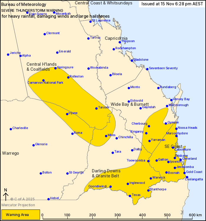
For people in Southeast Coast and parts of Central Highlands and
Coalfields, Wide Bay and Burnett, Maranoa and Warrego and Darling
Downs and Granite Belt Forecast Districts.
Issued at 6:28 pm Saturday, 15 November 2025.
Severe thunderstorms continue through southern Queensland
Weather Situation: Severe thunderstorms continuing in a moist
unstable airmass this afternoon. Storms may move into or redevelop
along the southeast coast into the evening.
Severe thunderstorms are likely to produce heavy rainfall that may
lead to flash flooding, damaging winds and large hailstones in the
warning area over the next several hours. Locations which may be
affected include Warwick, Gold Coast, Toowoomba, Brisbane,
Maroochydore, Ipswich, Kingaroy, Cleveland, Gatton, Jimboomba,
Coolangatta, Stanthorpe, Caboolture and Goondiwindi.
Severe thunderstorms are no longer occurring in the Central West
district and the warning for this district is CANCELLED.
7 CM HAIL WAS REPORTED AT SILVER SPUR AT AROUND 2:00 PM.
61 MM WAS RECORDED AT MT BERRYMAN ROAD IN THE 30 MINUTES TO 3:45
PM.
56 mm was recorded at Nindooinbah Dam in the 1 hr to 5:30
pm.
55 mm was recorded at Upper Lamerough in the 30 minutes to 5:20
pm.
50 mm was recorded at Bogarella Crossing in the 1 hour to 5:17
pm.
55 mm was recorded at Mulgowie Rd in the 30 minutes to 3:50
pm.
52 mm was recorded at Rockside Mt in the 30 minutes to 3:45
pm.
Emergency services advise people to:
* Park your car undercover away from trees.
* Close doors and windows.
* Keep asthma medications close by. Storms and wind can trigger
asthma attacks.
* Charge mobile phones and power banks in case the power goes
out.
* Put your pets somewhere safe and make sure they can be
identified in case they get lost.
* Do not drive now unless you have to because conditions are
dangerous.
* Tell friends, family and neighbours in the area.
* Go inside a strong building now. Stay inside until the storm has
passed.
15/Nov/2025 09:26 AM

