
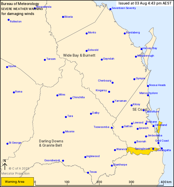
Source: Bureau of Meteorology
For people in parts of Southeast Coast and Darling Downs and
Granite Belt Forecast Districts.
Issued at 4:43 pm Sunday, 3 August 2025.
Damaging wind gusts possible over the Border Ranges and southern
Moreton Bay islands from this afternoon.
Weather Situation: A low pressure system offshore of the North
Coast of New South Wales brings strong south to southeasterly flow
to elevated and exposed coastal parts of southeast
Queensland.
Strong southerly winds averaging 50 to 60 km/h with DAMAGING WIND
GUSTS of around 90 km/h are possible over the southern Moreton Bay
islands and elevated parts of the Main Range and Border Ranges from
this afternoon.
Winds are forecast to ease below warning thresholds by early hours
of Monday morning.
A separate Coastal Hazard Warning is also current for the
southeast coast. Please refer to
http://www.bom.gov.au/qld/warnings/
Locations which may be affected include Springbrook and North
Stradbroke Island.
Emergency services advise people to:
* Park your car undercover away from trees.
* Close doors and windows.
* Keep asthma medications close by. Storms and wind can trigger
asthma attacks.
* Charge mobile phones and power banks in case the power goes
out.
* Put your pets somewhere safe and make sure they can be
identified in case they get lost.
* Do not drive now unless you have to because conditions are
dangerous.
* Tell friends, family and neighbours in the area.
* Go inside a strong building now. Stay inside until the storm has
passed.
03/Aug/2025 07:06 AM


