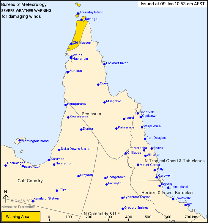
Source: Bureau of Meteorology
For people in parts of Peninsula Forecast District.
Issued at 10:53 am Friday, 9 January 2026.
Damaging winds developing about the Torres Strait and northwest
Cape York Peninsula today.
Weather Situation: The monsoon trough is situated over far
northern Cape York Peninsula and is expected to slowly move south
over the coming days. A strong burst of monsoonal northwesterly
winds is likely develop to the north of the trough during today,
bringing the risk of damaging winds to the northwest of Cape York
Peninsula and the Torres Strait islands.
Strong to DAMAGING WINDS averaging 55 to 65 km/h with peak gusts
of 90 km/h are possible about northern parts of Cape York Peninsula
and Torres Strait Islands, including Thursday Island, from this
afternoon. Winds are expected to persist through Saturday before
easing early Sunday morning.
Bursts of moderate rainfall in squally monsoonal showers and
thunderstorms are also expected.
A separate Severe Weather Warning and forecast track map
associated with Tropical Low 12U is current for people in the
northeast tropical coast. Several flood watches and warnings are
also current for large parts of Queensland. Please refer to
https://www.bom.gov.au/weather-and-climate/warnings-and-alerts
Locations which may be affected include Thursday Island, Bamaga,
Old Mapoon and the Torres Strait Islands.
Emergency services advise people to:
* Park your car undercover away from trees.
* Close doors and windows.
* Keep asthma medications close by. Storms and wind can trigger
asthma attacks.
* Charge mobile phones and power banks in case the power goes
out.
* Put your pets somewhere safe and make sure they can be
identified in case they get lost.
* Do not drive now unless you have to because conditions are
dangerous.
* Tell friends, family and neighbours in the area.
* Go inside a strong building now. Stay inside until the storm has
passed.

09/Jan/2026 01:21 AM


