
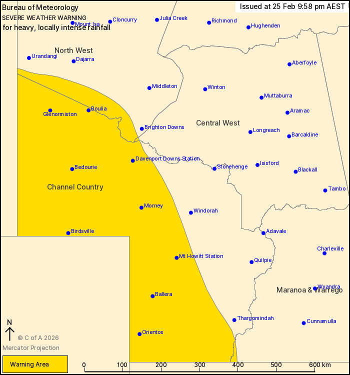
Source: Bureau of Meteorology
For people in Channel Country and parts of North West, Central
West and Maranoa and Warrego Forecast Districts.
Issued at 9:58 pm Wednesday, 25 February 2026.
HEAVY TO LOCALLY INTENSE RAINFALL IN THE FAR SOUTHWEST OF THE
STATE
Weather Situation: A slow-moving tropical low is located over the
southeast of the Northern Territory. Rich tropical moisture
surrounding this system is feeding into a trough in the southwest
of the state, with persistent thunderstorm activity
occurring.
HEAVY RAINFALL which may lead to FLASH FLOODING is likely, with
six hour rainfall totals between 50 and 80 mm. 24 hour rainfall
totals between 60 and 100 mm are likely, with isolated totals to
130 mm possible.
Locally INTENSE RAINFALL which may lead to DANGEROUS AND
LIFE-THREATENING FLASH FLOODING is also possible with slow-moving
lines of thunderstorms overnight into Thursday morning. Six hour
rainfall totals of around 110 mm are possible.
Showers and thunderstorms associated with the tropical low may
affect the western Channel Country for much of the week.
These conditions also threaten cattle and other livestock.
Separate Flood Watches and/or Warnings are current at the time of
issue. Please refer to
https://www.bom.gov.au/weather-and-climate/warnings-and-alerts/ for
more information.
Locations which may be affected include Birdsville, Boulia,
Bedourie, Ballera, Orientos and Glenormiston.
Emergency services advise people to:
* If you have children make sure they are with you or an adult you
trust.
* Park your car undercover away from trees.
* Close doors and windows.
* Keep asthma medications close by. Storms and wind can trigger
asthma attacks.
* Charge mobile phones and power banks in case the power goes
out.
* Put your pets somewhere safe and make sure they can be
identified in case they get lost.
* Do not drive now unless you have to because conditions are
dangerous.
* Tell friends, family and neighbours in the area.
* Go inside a strong building now. Stay inside until the storm has
passed.
25/Feb/2026 12:04 PM

