
Source: Bureau of Meteorology
Issued at 4:10 pm Friday, 13 February 2026.
Isolated heavy falls possible about parts of Southeast Queensland
this evening.
Weather Situation: A trough lying across Southeast Queensland and
a low offshore of the Sunshine Coast are capable of producing heavy
falls this evening. There is large uncertainty with where the areas
of highest rainfall will occur. Rainfall is likely to broadly ease
later tonight, but local heavy falls may be possible into the
weekend.
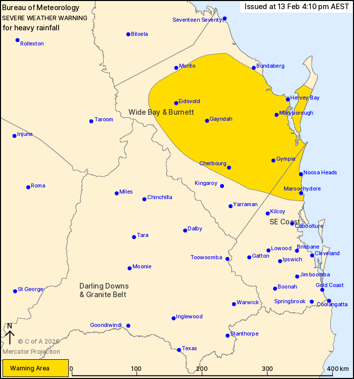
HEAVY RAINFALL which may lead to FLASH FLOODING is possible over
parts of the Wide Bay Burnett and South East Coast districts north
of Brisbane this evening. Six-hourly rainfall totals between 50 to
100 mm are likely, with isolated higher falls to around 150 mm
possible.
A separate Severe Thunderstorm Warning will be issued if VERY
DANGEROUS THUNDERSTORMS with INTENSE RAINFALL are detected. Other
Severe Thunderstorm Warnings are also possible over broader parts
of the state today.
A separate Flood Watch and various Flood Warnings are current at
the time of issue. Please check
https://www.bom.gov.au/weather-and-climate/warnings-and-alerts for
latest information.
Locations which may be affected include Maroochydore, Gympie,
Noosa Heads, Hervey Bay, Cherbourg and Gayndah.
59mm was recorded at Yarrol (Burnett River) in the 1 hour to
5pm.
157mm wa recorded at Tallebudgera Creek in the 6 hours to
11:35am
188 mm was recorded at Currumbin Creek in the 6 hours to
10:21am
Emergency services advise people to:
* Park your car undercover away from trees.
* Close doors and windows.
* Keep asthma medications close by. Storms and wind can trigger
asthma attacks.
* Charge mobile phones and power banks in case the power goes
out.
* Put your pets somewhere safe and make sure they can be
identified in case they get lost.
* Do not drive now unless you have to because conditions are
dangerous.
* Tell friends, family and neighbours in the area.
* Go inside a strong building now. Stay inside until the storm has
passed.
13/Feb/2026 06:34 AM

